Showing posts with label Great Smoky Mountains. Show all posts

Sunday, July 14, 2013

Man Sentenced For Vandalism at Max Patch

The Smoky Mountain Hiking Blog: Man Sentenced For Vandalism at Max Patch: The U.S. Attorney’s Office, in conjunction with the U.S. Forest Service, today announced that Tyler Pace was sentenced to 90 days incarceration by United States Magistrate Judge Dennis Lee Howell for vandalizing parts of Max Patch, a scenic area in the Pisgah National Forest in North Carolina.

"This sentence sends a message to vandals that damaging our public lands will not be tolerated," said United States Attorney Anne Tompkins.

Pace received the sentence during an appearance in U.S. District Court in Asheville on July 9, 2013. Prior to his sentencing hearing, Pace paid restitution for his share of the damage to Max Patch.

Pace was with a group of men who illegally drove vehicles in the Max Patch area in January 2013, causing more than $5,000 of damage to that scenic area. Pace facilitated that damage by tearing down the entrance gate and fence, thereby enabling the other persons to drive their vehicles into the protected area where vehicles are prohibited. Pace is 24 years old and a resident of Canton, North Carolina.

Max Patch sits next to the Tennessee state line in the Harmon Den area and is intersected by the Appalachian Trail. At 4,629 feet this bald offers 360-degree vistas of Mount Mitchell to the east and the Great Smoky Mountains to the southwest. An abundance of ferns and grasses blanket the area making it perfect for picnics.

The case was prosecuted by Assistant United States Attorney Richard Edwards.


Jeff

Tuesday, May 7, 2013

Celebrate National Trails Day in the Smokies on the Appalachian Trail

The Smoky Mountain Hiking Blog: Celebrate National Trails Day in the Smokies on the Appalachain Trail:

Celebrate National Trails Day in the Smokies on the Appalachian Trail

Saturday, June 1st, is the 21st annual National Trails Day. Friends of Great Smoky Mountains National Park, the Regional Office of the Appalachian Trail Conservancy, and the Smoky Mountains Hiking Club invite you to participate in helping them take care of the Appalachian Trail in Great Smoky Mountains National Park.

The A.T. Maintainers Committee of the Smoky Mountains Hiking Club and the Appalachian Trail Conservancy are responsible for maintaining the A.T. and its facilities in Great Smoky Mountains National Park on a continuing basis. With your help on National Trails Day, projects are completed that otherwise would not be accomplished. Also, the registration fees are an important source of funds to make improvements at housing used by A.T. Ridgerunners, the volunteer SWEAT crew, and Rocky Top trail crew in the Smokies.

Now's a great time to register to work at this year's event. For registrations postmarked by May 16th, the fee is $20.00 (After May 16th, it's $25.00).

Registering early helps the Crew Assignment Committee get workers placed in work groups and increases your chance of being assigned to your hike/work preference. Workers will receive a commemorative t-shirt and a picnic at day's end. See the registration form for details!

The picnic will be at Metcalf Bottoms Picnic Area following the workday.

If you have any questions you can be email Holly Scott with Friends of the Smokies at hollys@Friendsofthesmokies.org or Phyllis Henry at phyllishenry@yahoo.com.


Jeff
Hiking in the Smokies

Saturday, May 4, 2013

Understanding WildLife In The GSMNP

Most visitors understand that feeding wildlife is against the law, but many people do not realize that disturbing park wildlife is also a violation of federal regulations and can result in fines and arrest.
The laws protecting park wildlife are contained in the Code of Federal Regulations. It states that “Willfully approaching within 50 yards (150 feet), or any distance that disturbs or displaces bear or elk is prohibited." In addition, feeding, touching, teasing, frightening, or intentionally disturbing wildlife is prohibited.

As a rule of thumb, if you approach an animal so closely that it changes its behavior, you have approached too closely. Instead use binoculars, spotting scopes and cameras with telephoto lenses to enjoy wildlife. Watch for any modification in an animal's behavior that indicates that you have approached too closely. Move away from the animal until you reach a distance at which the animal feels comfortable once again and resumes whatever activity it was engaged in before you approached.

Never feed wildlife or bait animals for closer observation or photography. Feeding park wildlife usually guarantees its demise.

Viewing Tips:

Viewing wildlife in the Smokies can be challenging because most of the park is covered by dense forest. Open areas like Cataloochee and Cades Cove offer some of the best opportunities to see white-tailed deer, black bear, raccoon, turkeys, woodchucks, and other animals. The narrow, winding road of Roaring Fork Motor Nature Trail encourages motorists to travel at a leisurely pace and sometimes yields sightings of bear and other wildlife. During winter wildlife is more visible because deciduous trees have lost their leaves.

Because many animals are most active at night, it can be advantageous to look for wildlife during morning and evening. It's also a good idea to carry binoculars. Some people like to sit quietly beside a trail to see what wildlife will come out of hiding. And don't forget to scan the trees—many animals spend their days among the branches.

Great Smoky Mountains National Park contains some of the largest tracts of wilderness in the East and is a critical sanctuary for a wide variety of animals. Protected in the park are some 65 species of mammals, over 200 varieties of birds, 50 native fish species, and more than 80 types of reptiles and amphibians.

The symbol of the Smokies, the American Black Bear, is perhaps the most famous resident of the park. Great Smoky Mountains National Park provides the largest protected bear habitat in the East. Though populations are variable, biologists estimate approximately 1,500 bears live in the park, a density of approximately two bears per square mile.

Of the 65 other mammal species documented in the park, the white-tailed deer, groundhog, chipmunk, and some squirrel and bat species are the most commonly seen. Over 200 species of birds are regularly sighted in the park, 85 of those migrate from the neotropics. Some 120 species nest here. Several bird species that are listed as Species of Concern breed here, making the park an important source for repopulating areas outside the park that are showing declines in the numbers of these birds.


Information Provided By GSMNP

Hiking And Backpacking With Black Bears In GSMNP

Black bear fur is usually a uniform color except for a brown muzzle and light markings that sometimes appear on their chests. Eastern populations are usually black in color while western populations often show brown, cinnamon, and blond coloration in addition to black. Black bears with white-bluish fur are known as Kermode (glacier) bears and these unique color phases are only found in coastal British Columbia, Canada.

Diet
American black bears are omnivorous: plants, fruits, nuts, insects, honey, salmon, small mammals and carrion. In northern regions, they eat spawning salmon.
Black bears will also occasionally kill young deer or moose calves.

Population
It is estimated that there are at least 600,000 black bears in North America. In the United States, there are estimated to be over 300,000 individuals. However, the Louisiana black bear (Ursus americanus luteolu) and Florida black bear (Ursus americanus floridanus) are threatened subspecies with small populations (see Legal Status/Protection).

Range
The American black bear is distributed throughout North America, from Canada to Mexico and in at least 40 states in the U.S. They historically occupied nearly all of the forested regions of North America, but in the U.S. they are now restricted to the forested areas less densely occupied by humans. In Canada, black bears still inhabit most of their historic range except for the intensively farmed areas of the central plains. In Mexico, black bears were thought to have inhabited the mountainous regions of the northern states but are now limited to a few remnant populations.

Behavior
Black bears are extremely adaptable and show a great variation in habitat types, though they are primarily found in forested areas with thick ground vegetation and an abundance of fruits, nuts, and vegetation. In the northern areas, they can be found in the tundra, and they will sometimes forage in fields or meadows.

Black bears tend to be solitary animals, with the exception of mothers and cubs. The bears usually forage alone, but will tolerate each other and forage in groups if there is an abundance of food in one area.

Most black bears hibernate depending on local weather conditions and availability of food during the winter months. In regions where there is a consistent food supply and warmer weather throughout the winter, bears may not hibernate at all or do so for a very brief time. Females give birth and usually remain denned throughout the winter, but males and females without young may leave their dens from time to time during winter months.

Reproduction
Mating Season: Summer.
Gestation: 63-70 days.
Litter Size: 1-6 cubs; 2 cubs are most common.
Cubs remain with the mother for a year and a half or more, even though they are weaned at 6-8 months of age. Females only reproduce every second year (or more). Should the young die for some reason, the female may reproduce again after only one year.

Height: 2-3 feet (.6-.9m) at shoulders
Length: 4-7 feet (1.2-2m) from nose to tip of tail
Weight: Males weigh an average of 150-300 lbs (68-158 kg), females are smaller. Exceptionally large males have been known to weigh 500-600 lbs .
Lifespan: Average lifespan is around ten years, though black bears can live upward of 30 years in the wild.

Should you encounter a black bear
Stay calm - DO NOT RUN (running may elicit a chase response by the bear).
Pick up children so they don't run or scream; restrain dog; avoid eye contact and talk in soothing voice.
If the bear stands up, he is NOT going to attack but is curious and wants a better sniff or view.
Back away slowly; if bear chomps jaw, lunges, or slaps ground or brush with paw, he feels threatened.
Slowly retreat from area or make wide detour around bear; don't crowd or block bear's escape route.

Note: Bear attacks on humans are extremely rare. A person is 180 times more likely to be killed by a bee and 160,000 times more likely to die in a car accident. Most injuries from black bears occur when people try to feed, pet, or crowd them. Bears will nip or cuff bad-mannered humans, as they will bad-mannered bears.  They are very strong and powerful animals; bears should always be treated with caution and respect.
 

Hiking And Backpacking In The Rain

1)    Use waterproof stuff sacks for your gear, especially clothing. Use them in different colors to indicate what type of gear is in each.

2)    As most of us do, use self-locking plastic bags to keep such items as matches, food, camera, first aid kit, books, maps, journal, cell phones,GPS,and if you use water mixers.

3)    If it is very warm and raining, remember that you can become cold from the moisture when hiking at a brisk pace. Gear up a bit and keep a steady, slow-to-moderate pace.
4)    Be a quick-change artist (our weather most certainly is) and keep an extra layer of dry clothing made very accessible.

5)    If you are hiking in intermittent rain, make sure your stops for water or snacks are during the dry moments on the trail.

6)    Take advantage of your “pit zips” and other ventilation devices in your rain clothing. Open and close them to either cool off or warm up.

7)    To keep your feet dry, put on your rain pants. These direct the flow of water down and over the waterproof exterior of your boots. If it’s too warm, gaiters will keep your feet dry for a while, but won’t keep the rain from dribbling through the tops of your boots.

8)    Be a speed eater. Keep snacks handy in your larger exterior pockets, a waste pouch or somewhere that you don’t have to take off your rain coat to open your pack and expose your gear to the weather. Be inventive.

9)    As I learned in my hike to Mt. Cammerer Firetower , just the vegetation, after a prominent rain, can make you as wet as a river otter. And, of course, trees will drip for quite a while after heavy rains. So when the sun comes out, initially keep your rain gear and pack cover on.
10) At the end of the hiking day, wring out your socks if they become wet and hang them up in your tent where your body heat can help them dry a little. (Better yet, stuff them inside your sleeping bag while you snooze.) If the next day is drier and sunnier, hang the wet socks up to dry outside. Then put them back on your feet for hiking if they’re not too wet, and save your dry backup socks for the end of the day as you enjoy camp with a warm beverage and some dinner in your stomach.

Thursday, May 2, 2013

Park Reopens Trails Damaged in 2011 Tornado

The Smoky Mountain Hiking Blog: Park Reopens Trails Damaged in 2011 Tornado: Great Smoky Mountains National Park officials announced today the reopening of two trails that have been closed since 2011 after receiving extensive damage from a F4 Tornado in the western end of the Park.

The Park's Trail Crew recently completed rehabilitation work on Beard Cane and Hatcher Mountain Trails. These trails have been closed since April 2011 due to damaging tornado winds and rain that left the trails blocked by thousands of downed trees. In addition, Park crews had to rebuild the trail tread surface and construct multiple retaining walls where the trail had been completely destroyed after uprooted trees fell downslope with sections of the trail attached.

After the 2011 tornado, 50 miles of trails were initially closed including Ace Gap Trail, Beard Cane Trail, Hatcher Mountain Trail, Little Bottoms Trail, Rabbit Creek Trail, Hannah Mountain Trail, Cooper Road Trail, Cane Creek Trail, Gold Mine Trail, and Abrams Falls Trail. Twenty-four trail crew employees from across the Park responded to the incident in addition to trail crews from Canyonlands National Park, Joshua Tree National Park, and Kings Canyon National Park. Due to the scope of the workload, coupled with the responsibility to maintain the other 800 miles of trails in the Park, Smokies Trail Crew Supervisor, Tobias Miller, reached out to fellow NPS trail crews from across the country to aid in tree clearing efforts and trail reconstruction.

“This was some of the most challenging work I have ever faced. I feel fortunate to have the opportunity to work with such hardworking professionals and the best trail crew in the NPS,” said Smokies Trail Crew Supervisor Tobias Miller. “It was clear from the first day, after I crawled through only three of the damaged trails, that we were in for some serious challenges to reopen these trails.”

All trails as a result of the tornado are now reopened for public use along with Backcountry Campsite 3. However, Backcountry Campsite 11 will remain closed. The damage to this site was so great from the storm that this location is no longer suitable as a campsite.

For more information about trail conditions, please visit the Park’s website at www.nps.gov/grsm or call our Backcountry Information Office at 865-436-1297.

You may want to note the following backcountry areas that are currently closed:

 • Chimney Tops Trail is closed due to a washed out bridge. The bridge is scheduled to be repaired by June 30. At that time, the park's Trails Forever Crew will begin Phase 2 of the ongoing trail rehabilitation project which will necessitate closing the trail each Monday through Thursday from July 1-October 17. The trail will be open weekly on Friday-Sunday during the rehabilitation project.

• Scott Mountain Trail from campsite #6 to Schoolhouse Gap. Campsite #6 is open.

• Backcountry Campsites 11, 54, 65

 • Noland Creek Trail will be closed from the trailhead to campsite #64 from April 22-May 2 for landslide repair. Campsite #64 will remain open.

• The bridge at the southernmost end of the Smokemont Loop Trail is closed due to construction in the area.


Jeff
Hiking in the Smokies

Saturday, April 27, 2013

Firefly Viewing Schedule - Passes Required Now

The Smoky Mountain Hiking Blog: Firefly Viewing Schedule - Passes Required Now: Park officials have announced the Elkmont Firefly Viewing event in Great Smoky Mountains National Park will take place from Thursday, June 6 through Thursday, June 13. For this year's viewing event, the on-line ticketing system, operated through Recreation.gov, will again provide visitors with parking passes to guarantee they will be able to park at Sugarlands Visitor Center without the inconvenience of having to arrive hours in advance.

Every year in late May or early June, thousands of visitors gather near the popular Elkmont Campground to observe the naturally occurring phenomenon of Photinus carolinus; a firefly species that flashes synchronously. In 2005 the Park began closing the Elkmont entrance road each evening and operating a mandatory shuttle bus system to and from the viewing area to provide for visitor safety, resource protection, and to enhance the experience for both viewers and campers at Elkmont.

In 2012, the Park instituted the reservation requirement for the first time. This was in response to the increasing popularity of the event which caused management issues in the parking area and congestion for visitors accessing the Sugarlands Visitor Center. The new system improved the visitor experience by allowing reservation holders to arrive later in the day and guaranteed access to the event.

For this year's event a parking pass will be required for all vehicles. The pass will cover a maximum of 6 persons in a single passenger vehicle (less than 19 feet in length). Four passes for oversize vehicles, like a mini bus (19 to 30 feet in length and up to 24 persons), will also be available. Each reservation will cost $1.50. Parking passes will be non-refundable, non-transferable, and good only for the date issued. There is a limit of one parking pass per household per season. Each reservation through Recreation.gov will receive an e-mailed confirmation and specific information about the event.

The number of passes issued for each day will be based on the Sugarlands Visitor Center parking lot capacity. Passes will be issued with staggered arrival times in order to relieve congestion in the parking lot and for boarding the shuttles.

The shuttle buses, which are provided in partnership with the City of Gatlinburg, will begin picking up visitors from the Sugarlands Visitor Center RV/bus parking area at 7:00 p.m. The cost will be $1 round trip per person, as in previous years, and collected when boarding the shuttle.

The shuttle service will be the only transportation mode for visitor access during this period, except for registered campers staying at the Elkmont Campground. Visitors will not be allowed to walk the Elkmont entrance road due to safety concerns.

The parking passes for this year's event will be on sale on-line beginning after 10:00 a.m. April 29. The Park will hold back 90 passes for each day to accommodate individuals who did not learn of the need to pre-purchase tickets. Those last 90 passes will go on sale on-line at 10:00 a.m. the day before the event and will be available until 3:30 p.m. on the day of the event or until the passes are all reserved.

Passes can be purchased at www.Recreation.gov. Parking passes may also be obtained by calling 1-877-444-6777but Park officials strongly encourage the use of the on-line process, because it provides far more information to visitors about what to expect when they arrive at the Park. The $1.50 reservation fee covers the cost of processing the requests for the passes. The Park will not receive any revenue either from the reservations or the shuttle tickets.


Jeff
Hiking in the Smokies

Wednesday, April 24, 2013

Updates on Flood Damaged Trails in the Smokies

The Smoky Mountain Hiking Blog: Updates on Flood Damaged Trails in the Smokies: Great Smoky Mountains National Park crews are making needed repairs on both Chimney Tops Trail and Noland Creek Trail which received significant flood damage this winter.

In Tennessee, the popular Chimney Tops Trail has been closed since January when high waters destroyed the pedestrian bridge across Walker Camp Prong at the beginning of the trail. Crews are working to replace the 70-foot long bridge to allow trail access and estimate reopening the trail by June 30th, 2013. At that time, the Park's Trails Forever Crew will begin Phase 2 of the ongoing full trail rehabilitation which will necessitate closing the trail each Monday through Thursday from Monday, July 1 through Thursday, October 17, while the trail continues to undergo a major facelift.

In North Carolina, Park crews will repair a slide area along Noland Creek Trail. In order to make the needed repairs, the trail will be closed to all hiker and horse use from April 22 - May 2, 2013 from the trailhead to Backcountry Campsite 64. Note that Campsite 64 will remain open, but Backcountry Campsite 65 will be closed during the project.

During the January 30th storm, the Great Smoky Mountains received more than 4 inches of rain in 24 hours, resulting in flooding of streams throughout the park which were already swollen from higher than normal precipitation throughout the month. Average rainfall during January across the Smokies usually averages 5-7 inches of rain, but the park received 14-17 inches of rain during the month.

Other backcountry closures you should be aware of include:

• Beard Cane Trail and campsites #3 and #11
• Hatcher Mountain Trail
• Scott Mountain Trail from campsite #6 to Schoolhouse Gap (campsite #6 is open)
• Backcountry Campsites 3, 11, 40, 54

For more information about trail closures, please call our Backcountry Information Office at 865-436-1297

Saturday, April 20, 2013

The Smoky Mountain Hiking Blog: Newfound Gap Road Reopens to Thru Traffic

The Smoky Mountain Hiking Blog: Newfound Gap Road Reopens to Thru Traffic: Great Smoky Mountains National Park officials announced the completion of road repairs to Newfound Gap Road (Hwy 441) this morning. The road has been closed since the January 16th landslide that washed away approximately 200 feet of the road. At 10:00 am on April 15th, the Park officially opened the road to all thru traffic between Cherokee, NC and Gatlinburg, TN.

Park Superintendent Dale Ditmanson, NC Congressman Mark Meadows, Eastern Band of Cherokee Indians Principal Chief Michell Hicks, and Federal Highways Administration (FHWA) Construction Operations Engineer Emmett Melton jointly announced the opening of the road this morning 30 days ahead of the scheduled completion date of May 15, 2013. The National Park Service, FHWA, Phillips & Jordan, Inc. (P&J), APAC Harrison Division, and all subcontractors worked cooperatively in the most efficient and expeditious manner possible to restore Hwy 441 to a safe byway for the traveling public, the gateway communities, and Great Smoky Mountains National Park.

The primary repair contract was awarded to P&J for the submitted bid of $3,989,890.00 with the completion date set at May 15, 2013. The contract included a monetary incentive of $ 18,000 per day to the each day of completion prior to May 15, 2013, up to a maximum of $504,000 offered jointly by the Eastern Band of the Cherokee Indian (EBCI) and the National Park Service.

"We recognize the economic importance of the road to our neighboring communities and are grateful that our partners at Federal Highways Administration and were able to respond efficiently to our need and work with the contractors to make the necessary repairs in less than 90 days," said Superintendent Ditmanson.

APAC Harrison Division completed Phase 1 of the reconstruction project on February 21, 2013 by developing the access road to the slide area, removing of debris, and stabilizing the slope above the work area. P&J mobilized equipment on February 22, 2013 to begin Phase 2 of the reconstruction project which included rebuilding the roadway and filling the area washed away during the landslide with crushed stone.

The final design includes over 200 feet of pipes to allow for the drainage of subsurface water flow along with 150 feet of side drainage leading to a culvert at the end of the slope. This drainage system and previous crushed stone material will further protect the road and park resources from future damage due to both overflow and subsurface water flow. The fill area was naturally sloped and planted with seed. In addition, erosion measures were put into place along the 900 foot debris field below the landslide which was also seeded.


Jeff
Hiking in the Smokies

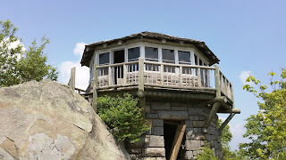
Mt. Cammerer FireTower In The GSMNP

Mount Cammerer is a mountain on the northeastern fringe of the Great Smoky Mountains, in the Southeastern United States. The mountain is situated on the state line between Cocke County, Tennessee and Haywood County, North Carolina. The Appalachian Trail traverses Cammerer's south slope and a restored fire lookout at the summit offers panoramic views of the eastern Smokies, Cocke County, and the Blue Ridge Mountains.

Although a narrow ridge connects Mt. Cammerer to a nearby higher knob, leaving Cammerer with a very low topographic prominence, the mountain is clearly visible not only from the surrounding mountains, but from various points in the town of Cosby and along I-40 as it crosses Cocke County. Mt. Cammerer is a popular hiking destination, especially in Autumn, when the leaves of the trees in the forest around the mountain blaze red, orange and yellow for as far as the eye can see.

History --

Mount Cammerer was named for Arno B. Cammerer, Director of the National Park Service (1933–1940) and an instrumental figure in establishing a national park in the Great Smoky Mountains. Before its renaming, Mt. Cammerer was known as "White Rock," referring to the bright white rocks that burst through the treeline at the summit. On some North Carolina maps, Mt. Cammerer is called "Sharptop". At least one story tells of a lightning blast that cut a hole in the summit, leaving a pool of water that attracted ravens.

Throughout the late-19th century and early 20th-century, moonshining was rampant in the area around Mt. Cammerer, as what was then a virgin wilderness provided the perfect cover for the illegal stills. Most residents in the area, however, were law-abiding mountain farmers, as described in local resident Mary Bell Smith's In the Shadow of the White Rock. Ella Costner, designated by the state of Tennessee as the "poet laureate of the Smokies," was born in the area of what is today the Cosby Campground, at the base of Mt. Cammerer. In 1934, the Civilian Conservation Corps built a camp at the base of the mountain, and constructed most of the trails and overlooks in the area.

The lookout at the summit of Mt. Cammerer was built by the CCC in 1937, using nearby rock and timber (other materials had to be hauled up the mountain). The tower was manned by a fire ranger until the 1960s, after which it fell into disrepair before being restored in 1996.

Hiking Routes --

The quickest route to the summit of Mt. Cammerer is to ascend the Low Gap Trail from the Cosby Campground to the Appalachian Trail at Low Gap. From Low Gap, it's just over two miles to the Mt. Cammerer Trail, which follows the ridge a half-mile or so to the summit. The total distance from the Cosby Campground to the summit is just over five miles.

The Lower Mount Cammerer Trail follows the mountain's northern base over a seven-mile up-and-down trail before intersecting the Appalachian Trail near Davenport Gap. Most hikers who use this route make the following loop: Cosby Campground , Lower Mount Cammerer Trail , Appalachian Trail , Cosby Campground. The Appalachian Trail intersects the Mount Cammerer tower trail along this route. The total distance, including the tower trail, is appx. 15 miles.

Multiple hiking trails, horse trails, and walkways intersect at the Cosby Campground, which can lead to confusion. From the parking lot (near the campground), one path leads east to the Lower Mount Cammerer Trail. To reach the Low Gap Trail, simply follow the path parallel to Cosby Creek. Both trails are marked.

Saturday, January 26, 2013

Smokies Announces Implementation of Backcountry Ca...

The Smoky Mountain Hiking Blog: Smokies Announces Implementation of Backcountry Ca...: Great Smoky Mountains National Park officials announced today that changes to its current backcountry reservation and permitting process will take effect on February 13, 2013. As reported last March, the National Park Service approved the park's proposal to begin collecting fees for use of the park's backcountry campsites and shelters. The changes include a $4 per person, per night fee for backcountry camping. The fee will be used to provide increased customer service for backcountry trip planning, reservations, permits and the backcountry experience.

A park-specific reservation and permit system, to which users will have 24/7 access, will allow backcountry campers to make reservations and obtain permits online from anywhere internet access is available. Reservations may be made at any time up to 30 days in advance, allowing maximum flexibility for those making last minute plans. Backcountry users will no longer be required to call the Backcountry Office to obtain reservations. Reservation and permit requests will also be accepted in person at the Backcountry Office, which is located at the Sugarlands Visitor Center.

Backcountry Office hours will be expanded with additional staff available to provide trip planning assistance both over the phone and in person. In addition, the park will expand its backcountry Ranger presence to better protect park resources through enforcement of food storage and other regulations and improved visitor education regarding Leave-No-Trace principles.

For more information about the changes, please visit the management page or call the park's Public Information Office at 865-436-1207. For general backcountry information or backcountry reservations, call the Backcountry Office at 865-436-1297. On February 13, backcountry reservations and permits will be available at www.smokiespermits.nps.gov.

Wednesday, December 5, 2012

Man Arrested for Breaking into Cars in the Smokies

The Smoky Mountain Hiking Blog: Man Arrested for Breaking into Cars in the Smokies:

From NPS Digest:

While conducting a surveillance operation on the morning of Sunday, December 2nd, a ranger saw what appeared to be a man breaking into a vehicle parked at the Chimney Tops Trailhead on Newfound Gap Road. The man then left the area in a Ford pickup. When rangers attempted to stop the truck on Little River Road west of Sugarlands Visitor Center, the man fled and continued to elude rangers until he exited the park at the Townsend Wye. Once outside the park, rangers turned over the pursuit to Blount County Sheriff’s Office deputies, who took the 38-year-old Tennessee man into custody after he crashed his truck.

Rangers and special agents subsequently confirmed the theft of property from a visitor’s Ford Explorer parked at Chimney Tops Trailhead. The investigation of the offenses occurring within the park continues; federal charges are anticipated.


Jeff
Hiking in the Smokies

Tuesday, November 27, 2012

Discover the Joys of Winter Hiking

The Smoky Mountain Hiking Blog: Discover the Joys of Winter Hiking: Many hikers tend to run from the woods as soon as the first snow flakes begin to fall. However, winter is great time to hit the trail. Not only are the crowds gone, but many parks show off their true beauty after a fresh snowfall. With just a little more attention to detail beforehand, anyone can have a safe and enjoyable hike during the winter.

Although it might feel quite frigid at the trailhead, your body will begin generating plenty of heat after just 10 or 15 minutes of walking. The best thing you can do to keep the cold out is to dress in layers: a base layer that wicks moisture off your body, a fleece jacket for insulating warmth, and a shell to keep you dry and to keep the wind from penetrating your core. Most importantly, dressing in layers allows you to adjust your attire as you heat-up or cool-off. When dressing for a winter hike, always remember the adage: cotton kills! Never wear anything made of cotton while hiking in the backcountry. Once wet, cotton no longer insulates you from the cold. Moreover, it wicks heat away from your body and puts you at risk of becoming hypothermic.

Some people are prone to cold feet in the winter. One of the keys to keeping your feet warm is to make sure they stay dry. Wear a good pair of hiking socks, made of wool blends or synthetic fabrics, that wick moisture away from your skin, retain heat when wet, and dry faster if they become wet. I always keep an extra pair in my pack in case the ones I’m wearing do get wet. (Expert Advice: How to Choose Socks) You should also wear above-the-ankle hiking boots which help to keep snow away from your feet. You may want to consider wearing gaiters, especially if there are several inches of snow on the ground.

To round-out your winter apparel, don’t forget about a good pair of gloves, a ski cap and maybe even a balaclava.

If the snow is too deep in the mountains, consider hiking at lower elevations, or even wearing snowshoes. If you expect a lot of ice, especially in areas where there might be steep drop-offs, consider bringing crampons specifically made for hiking. These are sometimes referred to as traction devices, or in-step crampons, which you can either strap-on or slide onto your boots.

Trekking poles are another excellent choice for helping to maintain your balance on sections of trail with slick ice and snow.

After outfitting yourself with the proper winter gear, hikers will then need to focus on staying hydrated and properly fueled while out on the trail. Hiking in the cold, especially in snow, burns more calories. By some estimates, hikers can burn as much as 50% more calories when compared to similar distances and terrain in the summer. By not consuming enough calories while on the trail you become prone to getting cold faster. Make sure you bring plenty of high-energy snacks with you to munch on periodically throughout your hike. Watch out for foods that can freeze solid, such as some power bars. Or, instead of storing in your backpack, put some snacks inside your fleece jacket. Your body should generate enough heat to prevent them from freezing.

Although it may sound counter-intuitive, it can actually be easier to experience dehydration in the winter, versus hiking in the summer. Dehydration can occur faster in cold weather because the air is much drier. Moreover, dehydration can be dangerous because it can accelerate hypothermia and frostbite. Make sure you bring plenty of liquids with you, and drink often while on the trail.

If you’re storing water bottles in your backpack during a very cold day, you may need to insulate them to prevent them from freezing. An old wool sock will work in this case. Also, you may want to turn the bottle upside down to prevent the water from freezing at the neck. If you plan to be out for several hours, consider bringing a thermos containing a hot drink, or even soup.

Other winter hazards hikers need to be aware of include hiking in steep terrain that’s prone to avalanches, or a storm that covers the trail with fresh snow, thus making navigation difficult. You should always carry a topographical map and a compass with you in case you ever need help finding your way back to the trailhead if you were to become lost.

Other gear to bring with you includes a first aid kit, firestarter, waterproof matches, a pocket knife, an emergency blanket and maybe even a bivy sack.

Finally, let someone know where you’re going, when you’ll be back, and who to call if they don’t hear back from you at a specified time.

With a little care and preparation up front, anyone can discover the joys of winter hiking.


Jeff
Hiking in the Smokies

Tuesday, November 20, 2012

Hike To Indian Flats Falls In GSMNP

Trailhead of Middle Prong Trail the way to Indian Flats Falls

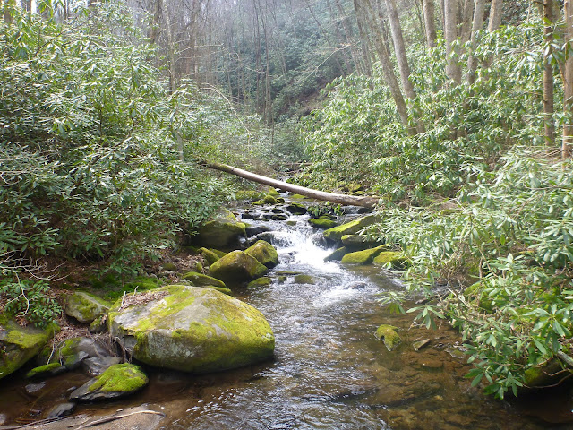
A beautiful hike that follows Middle Prong Creek

This is a really cool water slide to go down in the summertime

Trail bridge going over a small creek

Very old fire place out in the middle of no where

A small group of butterflies

Mother natures art work deep in the woods ..... so beautiful

Old service road bridge across the creek

Almost to Indian Falls

Indian Falls Waterfall ... 3 waterfalls in one

Second falls down from Indian Flats

I love waterfall hikes so much

This was spooky a rock that spelled out my intials in moss ...... M G

Monday, November 12, 2012

Hike To Meigs Creek And Meigs Mountain


If your wanting a very peaceful , very relaxing hike with not a whole lot of people then this is the hike for you . This is an easy hike with lots of creek crossings , a few waterfalls and wild ferns ( or better known as New York Ferns ). Meigs Creek Trail is 3.5 miles to Meigs Mountain Trail is another 2.4 miles from the junction .


Meigs Creek Trailhead

This is such a peaceful hike and a beautiful one also

Mountain Laurel blooming on the trail


Lots of creek crossings on this hike over 17 all together

This is Atti Falls on Meigs Creek Trail

Such a relaxing hike next to Meigs Creek

Lots of wild ferns growing everywhere on this trail

Morning dew laying on the grass and wilflowers

Almost to the Meigs Mountain Trail junction

The blades of the forest floor holds the tears of the clouds

I love the wildflowers and ferns on this hike

Alien Tree ? ............ LoL

Hiking Is Ageless

Sometimes it is not just the beauty of the scenery around you while hiking in the mountains of The Great Smoky Mountains National Park but the amazing people that you meet during your journey through the woods. Oh don't get me wrong the beauty of the smokies are really hard to beat in all ways but sometimes the people you meet just make that hike that your taking just that more enjoyable for anyone at any age.

Thoughout my years of hiking through the Great Smoky Mountains I have run into a lot of extraordinary people over the years from ages of 6 to 89 . Yes i said 89 years old ! People from all over the world , Poland to Brazil , Russia to Australia. Well if you think about it who in their right mind could be in a bad mood while hiking in the great outdoors . I would have to safely say that 98 % of all people i have encountered while hiking has always be very nice and always in a great mood . I have only run into 2 people that was in bad moods or was not enjoying theirselves .
Out of all of my encounters over the years of hiking 3 have really stood out in my mind and will probably stay with me as long as I am still on this earth .

1. I was going on a hike to Mt.LeConte via Alum Cave Bluff , I thought that I had got to the trailhead early that day arriving just a little before 8am but a little later I would find out that I was wrong. I was enjoying my hike up it was a beautiful day and not all the crowds had got there yet . Most people just hike to Alum Cave Bluff  4.4 miles round trip , this is a moderate hike with a total elevation change of 1125 ft. So I am going at a pretty good pace and about 0.8 of a mile from the top when this older gentleman comes around the the corner on his way back down. So we both stopped and started talking that is when i was blown away ! He was a man that was from Huntsville , Alabama and he was going back down already it was only 10:15 am . What so amazing about this ? Well he was 89 years old and had already gone up to Mt.LeConte and was on his way back down . He comes to the Great Smoky Mountains 5 times a year to go hiking and really enjoys it especially after his wife had died , he said it feels like he is closer to her .(I almost cried on that one ) This man was amazing to me he started out at the trailhead at 5:30 that morning and it was 10:15 and he was on his way back down . How many people do you know that is 89 that could walk 11 miles let alone hike 11 miles up a strenuous hike with a elevation change of almost 2800 ft. I just hope I am hiking like him at his age !

2. I met a wonderful family from Hillsborough, North Carolina hiking up to Ramseys Cascade in the Great Smoky Mountains National Park on the Greenbrier side of the park . This was a very nice family as most families that you meet out on the trail , what was so extraordinary about this family was their daughter . I have never enjoyed hiking back down a trail as I did this day with this young lady . She talked to me basically all the way back down but you ask what is so extraordinary about this? Well I will tell you , I know a lot of people and this little girl who was 10 was more intelligent than most adults that I know . It was such a pleasure to not only talk to her but to listen to her . She talked about a wide range of topics and made everyone of them very interesting to listen to her . This young lady was very amazing and I expect one day I will hear something very great about her . This is one of those hikes that you wish would never end .

3. I was hiking up BullHead on my way to Mt.LeConte and then on out to Myrtle Point ( which btw if you hadn't is well worth the extra mile ) . A little over a mile from the top i ran into 2 young men who just happen to be 17 year old twins almost the same age as my twin daughters . We started hiking together on our way to Mt.LeConte Lodge , we talked about hiking and school  and when we got to the lodge we split up . I was just finishing up my lunch when they both come back over to me and started talking some more . I told them I was going to the Cliff Tops and they asked if they could tag along and I said sure so they asked their dad  and he said sure . So I took them up there and we talked and enjoyed the view and just sat and talked about everything .Then I told them that I was going to head up to Mytrle Point , they again asked if they could follow along with me . Of course I said sure these two young men were very inquisitive about hiking and the Great Smoky Mountains National Park and the great outdoors . You could just tell that these twins put 100 % into everything that they do . It was such a pleasure to meet both these young men , who was very intelligent , very well - mannered and just loved life .

This is why I love hiking so much not only the scenery and nature is so beautiful but the people you meet are too . They're so many more encounters of extraordinary people that you meet while out on the trails of the smokies , these are just the ones that have left a lasting impression on me that I will never forget . This is why i say Hiking Is Ageless because people of all ages enjoy hiking , being outdoors and being part of something that in the end makes us all better people .

Happy Hiking ,
Atti's Taxi - Matt G.

Sunday, November 11, 2012

Park to Conduct Prescribed Burns of Cades Cove Meadows

The Smoky Mountain Hiking Blog: Park to Conduct Prescribed Burns of Cades Cove Meadows : Fire Management personnel at Great Smoky Mountains National Park plan to conduct a series of prescribed burns of fields in Cades Cove Monday through Friday, November 5th through 9th if weather conditions permit. Park managers plan to burn several tracts totaling about 570 acres.

The selected fields are being burned as part of a cost-effective strategy to prevent the open fields from being reclaimed by forest. The Park contracts to mow about 950 acres of fields that are clearly visible from the Cades Cove Loop Road twice a year. Other fields that are less visible from the Loop Road, totaling around 1,500 acres, are kept open by burning or mowing on a three year rotation. The seasonal prescribed burns encourage the growth of native warm-season grasses providing high quality cover and foraging opportunities for a diversity of wildlife including deer, turkeys, and ground nesting birds.

Without being either mowed or burned, the open meadows of the Cove would very quickly revert to pine and hardwood forest. That process would both alter the historically open landscape that characterized the Cove during its period of settlement and deprive Park visitors of the excellent wildlife viewing opportunities often found in the Cove.

The burn will be conducted by park Fire and Resource Management staff. Firefighters and fire engines will be assigned each day to ignite the grass lands and to make sure the fire stays within its designated boundaries. Strips of grass surrounding each field slated for burning have been mowed short to provide containment lines.  

Cades Cove Loop Road will remain open but visitors may experience brief delays due to smoke or other safety concerns as fire fighters work adjacent to roadways. "Motorists are asked to reduce speed in work zones and if smoke is present, keep windows up and headlights on," said Fire Management Officer Dave Loveland. "The public, of course, will notice smoke in the valley but it will dissipate quickly and not unduly impact their visit," he said.

Smokies officials are also planning a prescribed burn near Wears Valley for sometime between November 11th and 24th.


Jeff
Hiking in the Smokies

Friday, November 9, 2012

GSMNP Fall Color Report

November 9 Fall Color Report

Some very impressive areas of fall color linger at the park’s lower elevations (below 3,000’). Scarlet oak, northern red oak, the birches, sumac, and spicebush are especially vibrant. At the higher elevations, fresh snow crowns Mt. Le Conte and the Appalachian Trail ( Above 5,000 Ft.).

Suggested drives include Little River Road, Cades Cove, Gatlinburg Bypass, Roaring Forks Motor Nature Trail , the Foothills Parkway East (near Newport and Cosby), the Foothills Parkway West (near Townsend), The Foothills Parkway North (between Gatlinburg and Pigeon Forge—the “Spur”) and Cataloochee Valley.

Suggested trails and hiking destinations include Mingus Creek Trail, Cucumber Gap Loop, Old Settlers Trail, Deep Creek Trail, Gatlinburg Trail, Oconaluftee River Trail, and Abrams Falls.

Witch-hazel, the last flowering tree of the season, is in bloom.

Monday, November 5, 2012

Rescue of Hiker Trapped by Hurricane Sandy for 3 Days in Snowy Mountains


56-year-old North Carolina man, Steve Ainsworth was airlifted from the Appalachian Trail in Great Smoky Mountains National Park this past Friday afternoon. The hiker had become stranded on Appalachian Trail as a result of Hurricane Sandy's massive snowstorm that dumped over 3 feet of snow in the higher elevations of the Smoky Mountains National Park early last week.

Steve was was doing what is called a flip - flop ( where you hike one section of the Appalachian Trail and the flip to the reverse side ) . He was hiking southern part of the AT when Sandy hit and started snowing heavily for almost 3 days making the hiker literally almost trapped. He said it took him almost 8 hours to hike just one mile . He had encountered snow drifts over 5 feet high while hiking that distance . His feet was frozen , food and water almost out , he was forced to call 911 when he got a signal .

The rangers had tried to hike up to get him but they too had also hit the snow wall that Steve had run into only being able to hike a mile in many hours . Snow was just more than anyone could handle especially when your trying to hike through snow as tall as you are ! So on friday November 2 nd they contacted Tennessee Highway Patrol was called in for a air rescue . This is a video below of the rescue that they filmed getting Steve out of all that snow .


Saturday, November 3, 2012

Hike To Mt. LeConte Via Rainbow Falls After 3 Ft. Of Snow From Sandy Pt 5


These are pictures that I took on a hike from Rainbow Falls via Mt. LeConte after Hurricane Sandy had dumped over 3 feet of snow on Mt. LeConte and The Great Smoky Mountains above 5,ooo feet . Such beauty in the snow covered mountains makes everything so pure , so beautiful and so mysterious ! I hope you enjoy all the pictures . Happy Hiking !

Happy Halloween the day after ....... lol

Just November 1st and all this snow !

Solar Panels provide electricity for computer post

Picture perfect postcard

Besides the crew at the time i was up there only 4 people was at the lodge

Winter Wonderland in the Smoky Mountains

“Snow on one side of the canvas, silence on the other. I’d call that a perfect painting.”
― Jarod Kintz

Would like to thank the entire crew of Mt. LeConte Lodge for being so nice and all their hard work that a lot of people don't see to keep them happy and safe ..... Great Job and Thank you all