Wednesday, August 29, 2012

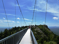
Grandfather Mountain Mile High Swinging Bridge


One of the great hikes at Grandfather Mountain is the trail to the mile high swinging bridge which is located near Linville Peak. The hike to the mile high swinging bridge is spectacular as it offers stunning views over the North Carolina high country. The hike is a loop that utilizes the Bridge Trail, the Grandfather Trail and the Grandfather Trail Extension.
Directions to Trailhead: The entrance to Grandfather Mountain is located on US 221, two miles north of Linville, North Carolina, and one mile south of the Blue Ridge Parkway at milepost 305. The street address for the entrance is: 2050 Blowing Rock Highway, Linville, NC 28646. The road to the summit is referred to as Grandfather Mountain Entrance Road, Linville, NC. Once inside Grandfather Mountain follow the road to the Grandfather Mountain trails parking area, there is a sign for the parking area just before you reach the Top Shop area at the end of the road. For a map of the location where Grandfather Mountain is click Here. For a map of trails at Grandfather Mountain click Here.

Description of Hike: The hike to the mile high swinging bridge at Grandfather Mountain is a loop that utilizes several trails. The trail is well maintained however much of the trail contains uneven rocks and roots from nearby trees. From the parking area take the Bridge Trail 0.4 miles to the Top Shop area. It is at this point that you cross the mile high swinging bridge (Actually it is more than a mile high), to Linville Peak which is 5,303 feet in elevation and provides great views of Grandfather Mountain and the surrounding North Carolina Mountains. Return back across the bridge and cross the parking area and take the Grandfather Trail to proceed back down to the parking area. In just under 0.4 miles from the Top Shop area at the mile high swinging bridge you will intersect with the Grandfather Trail Extension which will take you back to the the Trails Parking area at Grandfather Mountain. From the trail intersection to the Parking area is 0.6 miles for a total hike of approximately 1.6 miles roundtrip and approximately 350 feet of elevation gain. We would classify this as a moderate hike due to the intensity of the terrain. There is a fee per person to enter Grandfather Mountain, for current costs click Here. If you want a longer hike you can hike to MacRae Peak which is located at an elevation of 5,845 feet. This will add an additional 1.2 miles roundtrip and an additional 400 feet in elevation gain for a total hike of 2.8 miles and 650 feet of elevation gain, which we classify as strenuous. For more information about this add on to MacRae Peak click the link below.

Further Thoughts: The hike to Grandfather Mountain's mile high swinging bridge is a must do when you visit Grandfather Mountain. The terrain the hike goes through is unparalleled and the views continue to get better the higher up the mountain you go. We found that the trails were well marked and were well maintained by park staff. Additionally, since this is a popular hiking trail at Grandfather Mountain, you will likely see other visitors out enjoying the trails.

The Mile High Swinging Bridge was built to give visitors easy access to the breath-taking view from Grandfather Mountain's Linville Peak. The 228-foot suspension bridgespans an 80-foot chasm at more than one mile in elevation. Surveys by the staff at Grandfather Mountain have shown that the journey to the other side of the mile high swinging bridge is always considered the highlight of a trip to Grandfather Mountain.

The Mile High Swinging Bridge was originally constructed in 1952 and was rebuilt in 1999 using the original towers. The cables, floor boards and side rails were all replaced using galvanized steel. One of the main advantages of the modern building materials is that they do not have to be painted. Now Grandfather Mountain employees will not have to hang out over the gorge to paint the span. The 228-foot steel structure is America's highest suspension footbridge.


Rating: Elevation Gain: 350 ft. (Moderate), Distance: 1.6 Miles (Moderate).

Monday, August 27, 2012

FBI Offers 10,000 Dollars 4 Information On Murder Of AT Hiker

Federal authorities have offered a $10,000 reward for information leading to the conviction of the death of A.T. hiker Scott Lilly in Virginia last summer
Amherst, VA - The Federal Bureau of Investigation (FBI) is offering a $10,000 reward for information leading to the arrest and conviction of whoever killed Scott A. Lilly, 30, of South Bend, Ind., last summer near the Appalachian Trail in central Virginia.


FBI Special Agent Steve Duenas, the lead investigator, also disclosed at a news conference April 23 that Lilly “was buried.” Hikers found his “partially buried” body August 12, another agent said, along a side trail to Cow Camp Gap Shelter in George Washington–Jefferson National Forest in Amherst County, almost five miles north of the U.S. 60 Trailhead.

Duenas said Lilly’s last known contact was from the shelter July 31. He was not identified until August 16. That shelter is about 0.6 mile east of the A.T. along the Old Hotel Trail, which loops around and rejoins the A.T. again about two miles north.

A state medical examiner in January ruled the death a homicide and said the cause was “asphyxia by suffocation,” noted Mike Morehart, special agent-in-charge of the FBI’s Richmond office, who announced the reward.

Most of Lilly’s gear has not been recovered, he said, including new trail shoes (Walmart’s Ozark Trail brand), blue or purple backpack, a Nintendo game, and “an A.T. handbook.”

Lilly used the Trail name “Stonewall.” He had begun hiking south from Maryland in late June, intending to go all the way to Springer Mountain, resupplying periodically through Walmart gift cards sent by his mother, according to his family.


Hikes That Kids May Enjoy In The Great Smoky Mountains National Park

1.   Abrams Falls

Trail Features:   Waterfalls
 
Trail Location:       Cades Cove 
Roundtrip Length:      5.0 Miles 
Total Elevation Gain:   340 Feet 
Avg. Elev Gain / Mile:  136 Feet 
Highest Elevation:      1710 Feet 
Trail Difficulty Rating:  5.68 (moderate) 
Parking Lot Latitude    35.59077 
Parking Lot Longitude  - 83.85293


The 5-mile roundtrip hike to Abrams Falls is relatively short and is considered to be moderate in difficulty, thus helping to make it one of the more popular trails in the park and attracting nearly 1000 visitors per day during peak season.  
Although Abrams Falls is only 20 feet high, the large volume of water rushing over the cliff more than makes up for its lack of height. In fact, Abrams Falls is the most voluminous waterfall in the park. Although the long, deep pool at its base is very picturesque and inviting, swimming here is extremely dangerous due to strong currents and an undertow when close to the falls.

Kids love going swimming after hiking up to the falls durning the summer months.
The waterfall and the creek are named after Cherokee Chief Abram (or Abraham) whose village once stood several miles downstream.

2. Laurel Falls


Trail Features:  Waterfalls
 
Trail Location:     Little River Road 
Roundtrip Length:          2.3 Miles 
Total Elevation Gain:    314 Feet 
Avg. Elev Gain / Mile:   273 Feet 
Highest Elevation:         2677 Feet 
Trail Difficulty Rating:  2.93 (easy) 
Parking Lot Latitude     35.67208 
Parking Lot Longitude  - 83.58068


Roundtrip, the trail to Laurel Falls and back to the parking lot is 2.3 miles. You'll climb about 314 feet in elevation before arriving at the 80-foot waterfall. The hike is well worth it though - Laurel Falls is very photogenic!
The waterfall consists of an upper and a lower section, divided by a walkway which crosses the stream (Laurel Branch) at the base of the upper falls. The falls receives its name from the mountain laurel that blooms along the trail and near the falls in May.
If your goal is to go home with some excellent photos of the falls you may want to plan your hike for early in the morning or late in the day. The shade provided by the surrounding mountains will produce a much better picture.

The Laurel Falls Trail was built in 1932 to provide fire crews with access to the Cove Mountain area in the event of a forest fire. By the early 1960s, however, Laurel Falls had become a popular hiking destination for visitors, and erosion was taking a toll on the trail. As part of the 1963 Accelerated Works Projects grant to the Department of Interior, the trail to Laurel Falls was paved in order to halt the problems with erosion.


3. Grotto Falls


Trail Features:    Waterfalls, Old growth forest
 
Trail Location:    Roaring Fork Motor Nature Trail 
Roundtrip Length:           2.6 Miles 
Total Elevation Gain:       585 Feet 
Avg. Elev Gain / Mile:      450 Feet 
Highest Elevation:           3777 Feet 
Trail Difficulty Rating:    3.77 (easy) 
Parking Lot Latitude       35.68037 
Parking Lot Longitude   -83.46243


For the most part the trail is a gentle climb to Grotto Falls along a wide, well-worn path. As you proceed to the waterfalls you'll cross over four small streams without the benefit of a bridge.
At 1.2 miles hikers will reach a nice tumbling cascade. Just beyond this point, looking upstream, Grotto Falls comes into view for the first time.
The most distinctive feature about Grotto Falls is that it's the only waterfall in the Great Smoky Mountains National Park that a person can actually walk behind. The 25-foot high waterfall offers a cool, shady, and moist retreat for hikers in the summer. This same environment also provides an ideal habitat for salamanders as well.


As you walk behind the falls you can hear and feel the thunderous power of the water plunging into the pool in front of you. Watch your step here - especially in the winter - the area around the falls is always wet and slick.


4.  Hen Wallow Falls


Trail Features:         Waterfalls     
Trail Location:          Cosby     
Roundtrip Length:           4.4 miles     
Total Elevation Gain:      900 feet     
Avg. Elev Gain / Mile:     409 feet     
Highest Elevation:          2923 feet     
Trail Difficulty Rating:  6.20 (moderate)     
Parking Lot Latitude:      35.75719     
Parking Lot Longitude:   - 83.2087


Almost from the start, the path leading to Hen Wallow Falls begins to make a steady climb up the northern flank of Snake Den Mountain. While ascending Gabes Mountain Trail, which was once known as the Messer Trail, the roots and rocks on the pathway will testify how rough this trail is in some places. Although rugged, the trail passes through a beautiful lush-green forest of rhododendron and ferns, with hemlocks and yellow poplars that provide a nice overhead canopy.
After a short distance Rock Creek will appear on your right, and nearly 0.4 mile from the trailhead you'll pass a side trail that leads to the Cosby Campground. Shortly thereafter, the trail crosses over Rock Creek.
At roughly 0.7 mile you'll pass a social trail leading off to your right. Continue going straight here.

Roughly 1 mile from the trailhead you'll reach Messer Gap. There's another faint side trail on your right here that supposedly leads to an old grave site. To continue onto the falls hikers should go straight here. Just past this junction look towards your left and you'll see the remnants of an old rock wall from a former homestead.
At 2.1 miles you'll reach the short (and somewhat steep) side trail that leads down to the base of 90-foot Hen Wallow Falls. Although Hen Wallow Creek is only two feet wide at the top of the falls, it fans out to almost 20 feet at the base. We were fortunate to have visited the falls after quite a bit of rain. During the drier seasons throughout the year, water flowing over the cliff side can be a little low.


5. Clingman's Dome


Trail Features:    Scenic Views, Old growth forest , Highest point on Appalachian Trail &  In Tennessee

Trail Location:      Clingman's Dome Road

Roundtrip Length:          1.0 Miles 
Total Elevation Gain:      585 Feet 
Avg. Elev Gain / Mile:     585 Feet 
Highest Elevation:          6643 Feet 
Trail Difficulty Rating:   3.37 (easy) 
Parking Lot Latitude      35.562872

Parking Lot Longitude   -83.498496


Clingmans Dome is the highest point in the Great Smoky Mountains and in Tennessee.  From the top of the observation tower pictures above, one can, at times, see for over 100 miles in every direction. Unfortunately, these times are rare, and it is more common to be able to see for around 20 miles, which still provides outstanding views.
On my most recent trip to Clingmans Dome, however, the I was not even fortunate enough to see 20 miles. On rainy and cloudy days, the hike to Clingmans Dome is shrouded in fog, and limits views to only a few hundred feet.
One can actually choose from several different hikes to reach the observation tower. The most common route begins in the parking area 0.5 miles from the tower.
A paved trail leads from this area up a steep ascent. Along the trail, one will find a number of benches to rest. At each 0.1 mile there will also be a bench with a number indicating how many tenths of a mile you have walked.

Take your time on this popular trail as there are a number of potentially great views looking off into the Great Smoky Mountain National Park. Also be aware, however, that this is a very popular trail.

The forest surrounding Clingmans Dome received enough participation each year (mainly from near constant cloud coverage), that is considered a coniferous rain forest. As you walk up this trail, a community of spruce-firs lies along each sides of the trail.  These beautiful trees, however, are no longer a thriving community. Clingmans Dome received the highest levels of acid rain of any national park. Due to the constant precipitation left by the clouds and rain, the spruce firs are dying, and one will quickly notice the number of empty trunks and dead limbs in the area.

Once you reach the top of the trail, you will find a large circular stone area sitting below the 54 foot concrete observation tower. This tower is very accessible, and an easy climb to the top, as it is a long slow loop to the top with no stairs.

The top of the tower offers a 360 degree view  of the Great Smoky Mountains, Tennessee and North Carolina.

Temperatures on top of Clingmans Dome can be suprising, even on a warm spring day. Be prepared for moisture and temperatures that can be 20 to 30 degrees lower than the temperatures in the towns surrounding the mountain.

Nearby  Trails
Approach Trail from Newfound Gap – 7 miles
Appalachian Trail – 2181 miles
Mountain to Sea Trail – approximately 1000 miles (Clingmans Dome is the trail head of this trail)


Saturday, August 25, 2012

Star Event at Purchase Knob

The Smoky Mountain Hiking Blog: Star Event at Purchase Knob: Great Smoky Mountains National Park is hosting a star gazing event on Friday, September 7th at one of Haywood County's clearest views of the sky - Purchase Knob, home to the Appalachian Highlands Science Learning Center in Great Smoky Mountains National Park.


The Astronomy Club of Asheville will lead an exploration of the night sky at this high elevation site with a 260 degree unobstructed view of the sky. Visitors can expect to see the planets Neptune and Uranus; the wonderful starry glow of our Milky Way Galaxy stretching across Purchase Knob's dark skies; the beautiful spiral disk of the Andromeda Galaxy; the numerous star clusters of late summer and early fall; as well as several binary star systems.


National Park areas often offer a wonderful opportunity to stargaze, says park Superintendent, Dale Ditmanson. Visitors are often amazed at the amount of stars that can be seen simply by venturing out of the well-lit communities and into the natural darkness of Great Smoky Mountains National Park. National Parks across the country have begun to monitor and manage for natural night sky conditions in much the same way as we would to protect our air and water.


The event starts at 7:30 pm with an indoor orientation, which will be held rain or shine. The Learning Center is located at 5,000 feet in elevation so please bring warm layers. The program is limited to 60 people so reservations are required and can be made by calling the park directly at (828) 926-6251


Purchase Knob is located off US 276 near Maggie Valley, North Carolina. It is not recommended to use a GPS or an internet map service to find Purchase Knob, but the park staff can provide reliable directions.

Friday, August 24, 2012

Five Suicides Reported on the Blue Ridge Parkway

The Smoky Mountain Hiking Blog: Five Suicides Reported on the Blue Ridge Parkway : On Monday afternoon a trail runner found a 52-year-old Asheville man with a self-inflicted gunshot wound to his head, only a few feet off the Mountains-to-Sea Trail along the Blue Ridge Parkway. This was the 5th suicide in the park in just three weeks.
On Thursday, August 9th, rangers located the body of a 25-year-old Asheville woman with a self-inflicted gunshot wound to her head at the Rough Butt Bald Overlook.

On August 7th NPS Digest reported that Blue Ridge Parkway rangers investigated two separate suicides in the park on August 2nd and 3rd. On Thursday, Shenandoah dispatch notified Blue Ridge rangers that a bicyclist had seen a vehicle in a small gravel pullout off the parkway with an unresponsive woman inside who had a gun in her hand. They found the body of a 53-year-old North Carolina woman with a self-inflicted gunshot wound to her head. A note to her family was found in which she said that she’d been depressed and suffering from dependency on prescription drugs. On Friday, visitors found the body of a 43-year-old North Carolina man at a parkway overlook. Evidence indicated that he’d died from a drug overdose. The vehicle had been stolen from an acquaintance in Virginia and driven to the parkway, where it was found later that evening by some visitors who’d seen him at that same location earlier in the morning.

July 25th rangers and county officers found the body of a 41-year-old Georgia woman with a gunshot wound to the head at the Devil’s Courthouse Overlook.

A couple years ago Shenandoah National Park experienced a slew of suicides. In doing a little research at that time I found that the Centers for Disease Control (CDC), in conjunction with the National Park Service, conducted a study on suicide events (suicides and attempted suicides) in national parks between 2003 and 2009. During that time period 286 suicide events were reported from a total of 84 parks. 194 (68%) were completed suicides, and 92 (32%) were attempted suicides. Interestingly, the Blue Ridge Parkway had the highest number of deaths, as well as the highest number of total suicide events, according to that study.

Thursday, August 23, 2012

Fall Colors Good Predicted By WCU Foliage Forecaster

Visitors to Western North Carolina’s mountains can look forward to a good display of color this autumn, although some areas will enjoy brighter hues than others, predicts Kathy Mathews, Western Carolina University’s fearless fall foliage forecaster.

The intensity of the color show will vary depending on where leaf-peepers are looking because of fluctuations in the amount of rainfall received across the region this spring and summer, said Mathews. An associate professor of biology at WCU who specializes in plant systematics, she bases her annual prediction in part on weather conditions, including rainfall, during the spring and summer growing season.

“This should be a pretty good year for fall color, but colors will be spotty,” Mathews said. “Many areas of Western North Carolina have experienced a lot of rainfall throughout the year, while Asheville and points north have been drier. The drier areas should have the best fall color, while the wetter areas will be less vibrant.”
Mathews believes that the formation of higher levels of yellow, orange and red pigments in the leaves correlates with dry weather throughout the year. The drier the climate, the more brilliant the fall leaves tend to be, she said.

“This has been an unusually rainy spring and summer for much of Western North Carolina, which, if it continues through September and October, could mean less color, especially in the red range,” she said. “However, if evening temperatures continue to drop steadily through the next two months, it will hasten the loss of green from the leaves to reveal more yellow and orange pigments.”
In addition, a trend of warm, wet weather could equate to a longer fall color season. Mathews predicts that areas that have seen drought conditions, including the U.S. Midwest, may experience bright fall color, but only for a brief period before trees drop their leaves.
As is the case with predicting the weather, there are no guarantees when it comes to forecasting the intensity of the fall color season. Cloud cover and ample rainfall in the weeks ahead could mute the color show, Mathews said.

Cooler temperatures and fewer hours of daylight in the autumn contribute to the decomposition of chlorophyll, the chemical that gives leaves their green color in spring and summer. As chlorophyll breaks down, yellow and orange pigments – always present in the leaves, but masked by the green of chlorophyll – are revealed, and new red pigments are produced.

Depending upon the timing of the first frost, the peak of fall color should arrive during the second week of October in the higher elevations, and during the third week of October in the mid-elevations, Mathews said. Because freezing temperatures quickly degrade chlorophyll, leaves predictably peak in color a few days after a frost, she said.

The color change should begin at the higher mountain elevations in late September and continue through mid-November in the lower levels of WNC.
Regardless of when the peak is and how intense the hues are, visitors can always find good fall color somewhere in the WNC mountains, Mathews said.

“We have more than 100 tree species in the Southern Appalachians, which means not only many different colors of leaves in the fall, but also a lengthy fall color season. Some trees change and drop leaves very early, such as tulip poplar and yellow buckeye, while others linger and change later, such as oaks and hickories.”
The U.S. Northeast and Midwest have fewer tree species with good fall color, mainly sugar maples, leading to a short burst of brilliant colors, she said. “The same is true in the Western states, with color mainly coming from quaking aspens,” she said. “In Europe, again, there are many fewer tree species, meaning shorter, less diverse fall color than in the Southern Appalachians.”
From the Great Smokies to the Blue Ridge, the WNC mountains offer ample opportunity for leaf-looking this fall, Mathews said.

“Look for some of the best colors on Grandfather Mountain, the Graveyard Fields area of the Blue Ridge Parkway, and the Nantahala National Forest along U.S. Highway 64 between Macon and Clay counties,” she said. “These and other ridgetop areas show colors in all hues of red, orange and yellow. The forested areas will have a lot of yellow tulip poplars, red maple, and orange and red oak. Graveyard Fields also has a lot of shrubs that turn red.”

Wednesday, August 22, 2012

Merrell Adventure Rest - Guise and Charade

If you’ve flown on a plane recently, you’ve noticed the distinct lack of pillows on board. Sure, they’ll sell you one for $7, but who wants to pay for a terrible pillow you’ll never use again. As a result, many people bring along their own more comfortable neck pillows. The downside to this is that they’re bulky, and take up extra space in your luggage.

Merrell saw this as problem and figured out a solution. They created the Guise (Men’s) and the Charade (Women’s) jackets. Normally, these are Primaloft Eco insulated jackets that keep you nice and toasty on chilly days (or plane rides), but will convert into a neck pillow when needed. Thus, you can bring a jacket and a neck pillow in along for the ride.

As a jacket, the Guise is a water resistant insulating layer. Being water resistant, the Guise isn’t for summer downpours, but it will take a quick shower without a problem. The Primaloft Eco material is made from 50% recycled fibers and does the job quite well. Merrell thoughtfully included pit zips if you get too hot. Additionally, there are two hand pockets and one check pocket on the front.

Transforming the jacket into a pillow can be a bit awkward on a plane. You have to unzip a zipper on the inside of the jacket and essentially turn the jacket inside out. However, this does get the job done. The pillow itself isn’t as comfortable as a standalone neck pillow, but it’s quite a bit more comfortable than the $7 pillows they sell on board.
And if you don't fly this will make you a nice backpacking pillow !


Missing Hiker In The Sierras

Authorities are currently searching for a missing hiker in the Sierras after he failed to return and meet up with his friends on Sunday.

Inyo County sheriff’s department says that rescuers are currently searching for Gary Dankworth, a 60-year-old hiker and doctor from Carson City. Dankworth planned to solo climb the 13,855-foot Norman Clyde peak in the Palisades section of the Sierras. He had been camping with friends near Finger Lake in the John Muir Wilderness of Inyo National Forest. Norman Clyde peak is a rough and difficult climb–climbers must scramble over boulder fields, pass glaciers and hike along a narrow ridge with steep drop offs before even beginning to ascend the mountain.

When he didn’t return on Sunday, July 29, his friends alerted authorities and the search began the same day at about 1:30pm. Dankworth is 60 years old, and has black/grey hair and a mustache. He was last seen wearing a light gray hat, a tan long sleeve shirt, light gray pants, red boots and was carrying a day-pack with him.

We’ll be following the story closely and hoping that the sheriff’s department is able to find him safe.
Inyo County sheriff's spokeswoman Carma Roper says rescuers on Monday sought 60-year-old Gary Dankworth. Roper confirmed Dankworth is a doctor from Carson City.

The doctor was reported missing on Sunday, July 29. The search began that day around 1:20pm.
Dr. Dankworth is 60 years old, has black/gray hair, and a moustache. He was last seen wearing a light gray hat, a tan long sleeve shirt, light gray pants, red boots and a day-pack.

We called the office of Dr. Dankworth in Carson City and workers there didn't want to comment.
Dankworth left friends camped Saturday afternoon at Finger Lake in the John Muir Wilderness of Inyo National Forest to summit nearby, 13,855-foot Norman Clyde peak, a difficult climb in the rugged Palisades section of the Sierra that contains four of California's highest peaks

World’s oldest backpacker

A man described as the “world’s oldest backpacker” is poised to embark on his latest globe-trotting trip – at the age of 95.

Keith Wright,95 a pensioner from Queensland in Australia, will fly out to Europe on July 28, his eighth backpacking trip since he started travelling solo at the age of 85.

He has planned a two-month itinerary including Madrid, San Sebastian, Paris, Munich, Vienna and a trip to Britain to see the racing at Royal Ascot.

In the past decade, Mr Wright has visited many of the countries in Western and Eastern Europe, starting his backpacking a few years after his wife Barbara passed away.

His first trip was a bus journey through Turkey. Since then, he has travelled the world on a strict budget, saving up money throughout the year for flights and hostel accommodation.

Human Remains May be Linked to Missing Person Case

 Human Remains May be Linked to Missing Person Case:
Great Smoky Mountains National Park officials announced new developments yesterday in the case of Michael Giovanni Cocchini, a man thought to be missing in the Park since March.

On Friday, park employees discovered items thought to belong to Cocchini near the area where his vehicle was originally found parked along Newfound Gap Road. On Saturday and Sunday searchers combed the area where clothing and other items consistent with those last seen on Cocchini were located.

On Monday human remains were discovered in the area, but have not yet been positively identified. Cocchini’s family has been notified of the new developments.

The remains are being sent to the medical examiner for analysis and possible identification.

A search for Cocchini began on March 20th when rangers became suspicious after noticing that his vehicle had been parked for several days at a quiet walkway along Newfound Gap Road - approximately 1 mile south of the Park's Sugarlands Visitor Center. The walkway does not connect to the Park's trail system, so there would be no reason for backpackers to leave vehicles there overnight. The walkway is a short, easy, trail that extends into the woods a short distance off the road and then dead-ends at the West Prong of the Little Pigeon River.The seach for Micheal Cocchini and another hiker Derek Lueking had started back in March 18,2012 .

Monday, August 20, 2012

Be Aware Of Falling Rocks While Hiking

While some rock falls are unavoidable, individuals and groups can exercise a few measures to help prevent a falling rock mishap during a mountain hike or climb.

•Take careful, measured steps on a slope or hill to avoid dislodging rocks. Avoid letting rocks loose on fellow hikers by checking to see if any one is crossing the slope behind you.

•When on a steep slope, hikers and climbers should cross in a line diagonally, then form up and cross back, or go one at a time.

•If you dislodge a rock, warn hikers behind you with a loud yell of ‘‘rock!’’

•When you hear someone call out ‘‘rock,’’ do not look up. Turn to the side, and place your pack between you and the falling rocks.

•Watch and listen for rock falls and slides, especially during and after a thunderstorm or rain downpours.

•Never stand at places where rocks have obviously fallen before.

•Always be aware during strong winds because  falling trees can dislodge rocks also .

•Even snowfall can make rocks dislodge so always be aware while doing winter hikes .

•During winter hikes always be on the lookout for falling Icicles from trees but especially from bluffs and over hangs . ( These can be very dangerous especially falling from a couple 100 feet )

10 Better Ways to Hike In The Rain

Can you really have a successful hike through a waterlogged day or weekend? Sure—if you have the right attitude, and if you keep your gear dry. Here are 10 tips to help you out:

1. Waterproof stuff sacks are the way to keep dry clothes dry. Use different-colored sacks so you can easily identify where your gear is stashed. Garbage bags work as liners for non-waterproof sacks.

2. Self-locking plastic bags keep everything dry, from your food supplies to your journal, your matches, camera, first aid kit, guidebook, maps, and firestarter—among other things.

3. In hot climates, it can be pleasant to walk in the rain without rain gear, but if you start feeling cold, it’s time to gear up. Keep a slow, steady pace. You don’t want to overheat.

4. Be prepared by having an extra layer of clothes available where you can get to them fast in case of a sudden change in the weather.

5. Be flexible about stopping for breaks. In intermittent wet weather, take advantage of dry stretches to eat and drink—regardless of whether it’s your usual time. You’re burning a lot of calories walking and staying warm, and you need to replenish them.

6. Ventilation can regulate your temperature. If your rain gear has “pit zips”, open and close them to cool off or warm up.

7. To keep your feet dry, put on your rain pants. These direct the flow of water past your legs, over the waterproof outsides of your boots. If it’s too warm, gaiters will keep your feet dry for awhile, but won’t keep the rain from going in the tops of your boots.

8. Keep snacks handy in a waistpouch or somewhere else where you don’t have to take off your rain cover, open your pack, and expose your gear to the weather every time you want a snack.

9. When the sun comes out, keep your pack cover and gaiters on. Trees will be dribbling rain down onto you for several hours after the rain has stopped, and wet knee-brushing vegetation can soak feet in minutes.

10. If you end up with wet socks after the day’s hiking, wring them out and hang them up where escaping body heat will dry them a little. If next day is sunny, wear spare socks and hang wet ones on your pack to dry. If it’s still raining, put your already soggy socks back on your feet, and save the dry ones for the end of the day.

The more comfortable you are, the happier you will be for all of your hike.

Sunday, August 19, 2012

Signal for Help, SOS ( Wilderness Survival )

History Of The Appalachian Trail ( AT )

The Appalachian Trail was the brainchild of Benton MacKaye, a Massachusetts regional planner and forester for the United States Forest Service, as well as a cofounder of The Wilderness Society. His idea for a continuous wilderness trail was proposed in an October 1921 article in the Journal of the American Institute of Architects, entitled "An Appalachian Trail: A Project in Regional Planning." The trail was to provide leisure, enjoyment, and the study of nature for people living in the urban areas of the eastern United States.

Just two years later, on October 7, 1923, the first section of the Appalachian Trail, from Bear Mountain-Harriman State Park to Delaware Water Gap, was opened. MacKaye then called for a two-day Appalachian Trail conference to be held in March 1925 in Washington D.C., which resulted in the formation of the Appalachian Trail Conference (now called the Appalachian Trail Conservancy). Little progress, however, was made on the trail for several years.

The trail wasn't completed until August 1937 when the Civilian Conservation Corps connected the ridge between Spaulding and Sugarloaf Mountains in Maine. The 1968 National Trails System Act made the AT a linear national park and authorized funds to surround the entire route with public lands, either federal or state, and to protect it from incompatible uses. Roughly 2181 miles in length, the Appalachian Trail is the nation's longest marked footpath. It passes through 6 national parks and touches 14 states.

Although the Appalachian Trail was the brainchild of Benton MacKaye, it was Harvey Broome and Paul Fink that made it a reality in the Great Smoky Mountains.  
Harvey Broome was an early environmentalist, another one of the cofounders of The Wilderness Society, and a longtime president of the Smoky Mountains Hiking Club. He, along with seven others, hiked the 75+ miles of AT through the Park in 1932 before the trail was even completed. He was largely responsible for sighting most of the trail thru the Park.
  
Paul Fink, another leader of the movement that led to the founding of the Smoky Mountains as a national park, was also instrumental in blazing the AT through the Smokies. Fink was a member of the Board of Managers of the Appalachian Trail from 1925 to 1949, and was the author of "Backpacking Was the Only Way", an account of early 20th century camping and backpacking adventures in the southern Appalachians.

Myth Busted: Women aren't more prone to bear attack

Ever since the night of August 13, 1967, when two women were attacked and killed by grizzly bears in two separate incidents in Glacier National Park (which was later chronicled in Night of the Grizzlies), a myth has persisted that women may be more prone to bear attacks as a result of odors associated with menstruation.

However, according to a paper recently published by the National Park Service, "there is no statistical evidence that known bear attacks have been related to menstruation".

The report pointed towards evidence from previous studies:

* Stephen Herrero (1985) analyzed the circumstances of hundreds of grizzly bear attacks on humans, including the attacks on the two women in Glacier, and concluded that there was no evidence linking menstruation to any of the attacks. The responses of grizzly bears to menstrual odors has not been studied experimentally.

* Lynn Rogers et al. (1991) recorded the responses of 26 free-ranging black bears (Ursus americanus) to used tampons from 26 women and the responses of 20 free ranging black bears to four menstruating women at different days of their flow. Menstrual odors were essentially ignored by black bears of all sex and age classes. In an extensive review of black bear attacks across North America, no instances of black bears attacking or being attracted to menstruating women was found (Cramond 1981, Herrero 1985, Rogers et al. 1991).

The paper also mentions that between 1980 and 2011, 43 people have been injured by bears in Yellowstone National Park. 79% of those attacks occurred on men. Of the 9 incidents involving women, 6 were surprise encounters with bears while the women were hiking, and were therefore probably unrelated to menstruation.

The paper also notes that your risk of bear attack is highest while hiking in the backcountry. You can reduce the risks by:

1) hiking in groups of 3 or more people
2) staying alert
3) making noise in areas of poor visibility
4) carrying bear spray
5) not running during encounters with bears

Wednesday, August 15, 2012

10 Essentials You Might Need In Hiking

1.Appropriate footwear. For a short day hike that doesn’t involve a heavy pack or technical terrain, basic low-cut trail shoes are great. For longer hikes, carrying heavier loads, or more technical terrain, hiking boots offer more support. Always wear good-quality wool or synthetic socks that wick the moisture away from your feet.

2. Map and compass/GPS. A map and compass not only tell you where you are and how far you have to go, they can help you find campsites, water, and an emergency exit route in case of an accident. While GPS units are very useful, always carry a map and compass as a backup.

3. Extra water and a way to purify it. Without enough water, your body's muscles and organs simply can't perform as well. Consuming too little water will not only make you thirsty, but susceptible to hypothermia and altitude sickness.

4. Extra food. Any number of things could keep you out longer than expected: getting lost, enjoying time by a stream, an injury, or difficult terrain. Extra food with high nutritional value will help keep up energy and morale.

5. Rain gear and extra clothing. Because the weatherman is not always right. Dressing in layers allows you to adjust to changing weather and activity levels. Two rules: avoid cotton (it keeps moisture close to your skin) and always carry a hat.

6. Safety items: fire, light, and a whistle. The warmth of a fire and a hot drink can help prevent hypothermia. Fires are also a great way to signal for help if you get lost. If lost, you’ll also want the whistle, because it is more effective than using your voice to call for help. (Use 3 short bursts.) And just in case you’re out later than planned, a flashlight/headlamp is a must-have item to see your map and where you’re walking.

7. First aid kit. Pre-packaged first aid kits for hikers are available at any outfitter. Double your effectiveness with knowledge: take a first aid class with the American Red Cross or a Wilderness First Aid class.

8. Knife or multi-purpose tool. These enable you to cut strips of cloth into bandages, remove splinters, fix broken eyeglasses, and perform a whole host of repairs on malfunctioning gear.

9. Sun screen and sun glasses. Especially above treeline, where there is a skin-scorching combination of sun and snow, you'll need sunglasses to prevent snow blindness and sunscreen to prevent sunburn.

10. Daypack/backpack. You’ll want a well-fitted pack that you can carry comfortably. It should be outfitted with handy pockets and other features designed to keep you hiking smartly. Don’t forget the rain cover; some packs come with one built-in. Keep the other 10 Essentials of Hiking in the pack and you’ll always be ready to hit the trail safely.

Trail Advisories and Backcountry Warnings

Backcountry Facilities

For current backcountry trail and campsite information call (865) 436-1297 or (865) 436-1234. Please note these numbers are for backcountry trail and campsite information only.

Bear Warnings - areas where bears are active. Please read What Do I Do If I See A Bear? for important safety information about bears.
• Abrams Falls Trail
• Laurel Falls Trail
• Bullhead Trail
• Backcountry Campsites 34, 35, 62, 113
• Cosby Knob Shelter
• Derrick Knob Shelter
• Mount Le Conte Shelter
• Russell Field Shelter
Areas Closed Due to Bear Activity• Backcounty Campsites 13, 21, 24

Backcountry Areas Closed Due to Storm Damage or Trail Rehabilitation• Chimney Tops Trail will be closed Mondays through Thursdays, April 30 - October 18, for trail rehabilitation. more information...
• Ace Gap Trail
• Beard Cane Trail and campsites #3 and #11
• Chestnut Top Trail
• Goshen Prong Trail and campsite #23
• Gunter Fork Trail
• Hannah Mountain Trail and campsite #14
• Hatcher Mountain Trail
• Rabbit Creek Trail and campsites #15 and #16
• Scott Mountain Trail (campsite #6 is open, but is accessible only from Crooked Arm/Indian Grave Gap)
• West Prong Trail from Tremont Road to campsite #18. The trail is open from Bote Mountain Trail to campsite #18.The campsite is also open.

Trail CautionsPlease note that the park's backcountry is managed as a natural area where the forces of nature determine trail conditions. The following list includes some conditions that the park is currently aware of. However, hikers may encounter trail conditions not listed below that require caution. Be prepared for swollen streams, bridge washouts, downed trees, and trail erosion when hiking in the park's backcountry.
• Middle Prong Trail - The first bridge on this trail has undergone temporary repairs. Stock users are advised to walk stock across the bridge.
• Trails throughout the park, especially those on the western end, have numerous downed trees due to severe storms. Please see the list of closed trails above. Other trails may have areas that are difficult to negotiate due to downed trees.
• Boat shuttles to and from Hazel Creek when lake levels are low are from the Ollie Cove Trailhead on the Hazel Creek embayment. Ask the shuttle service about this when making a reservation to be dropped or picked up. This is due to a bridge that is out of service on Hazel Creek and adds about 1/2 mile to the hike. Ollie Cove Trail is new - trail signs are in place to direct you from the Hazel Creek Trail and Lakeshore Trail intersection to Ollie Cove Trail that is one mile east on Lakeshore Trail from Hazel Creek.

Temporary Road and Facilities Closures In GSMNP

Road Closed sign

August 9, 2012
Weather-related road and facility closures may change throughout the day. For updated road and weather information please call (865) 436-1200 (865) 436-1200 . Once you hear a voice, dial extension 631 for road information or extension 630 for a weather forecast.
Follow road status updates on Twitter at http://twitter.com/smokiesroadsnps. Updates are available for Newfound Gap Road (US-441), Little River Road, Laurel Creek Road, and Cades Cove Loop Road.
This webpage is updated 3-4 times a week. For the most current report, please call the number listed above or follow SmokiesRoadsNPS on Twitter.

Roads and Facilities
Seasonal ClosuresFor information about seasonal closures during the winter months, please see:
Seasonal Road Closures
Seasonal Facility Closures

Road Construction
• Newfound Gap Road (US-441) construction will continue throughout the summer on the Tennessee side near Newfound Gap. Motorists may encounter brief delays.
Temporary Closures Follow road status at http://twitter.com/smokiesroadsnps
• Chimney Tops Trail will be closed Mondays through Thursdays, until October 18, for trail rehabilitation. more information...
• Foothills Parkway (unfinished section) - the entire unfinished section between Walland and Wears Valley is now closed to all public use until 2015 due to construction.

Major Progress being made on Chimney Tops Trail

Christine Hoyer from the Trails Forever program recently posted a couple of photos highlighting some of the progress being made on the Chimney Tops Trail. It looks like they are making some major improvements, and I'm really looking forward to hiking up there once the project is completed.

The combination of heavy use, abundant rainfall, and steep terrain had turned the trail into a badly eroded obstacle course of slick, broken rock, exposed tree roots and mud. The hazards that existed on the trail encouraged hikers to pick their way across the uneven surface or to divert them off the edges of the trail, thus causing extensive erosion and resource damage.

The Park's Trails Forever Crew is currently rebuilding the trail using rock and timber. Work includes: constructing rock steps to carry hikers up the steepest areas and to prevent erosion; building elevated "turnpikes" - logs laid parallel and packed with dirt to carry the trail across wetland areas, and creating numerous "waterbars" - logs or stone partially buried diagonally across the trail to divert rainwater off the trail before it can erode the walking surface. Park managers say that the extensive use of durable stone and rot-resistant black locust timbers in the reconstruction will stabilize the trail for decades to come, reducing annual maintenance, and greatly improving the visitor experience.

Through October 18th, the trail is closed each Monday through Thursday while crews give the trail a facelift.