Trail Description:
If you're trying to decide which trail to take to Mount LeConte: the Rainbow Falls Trail or Bullhead, I would recommend taking the Bullhead Trail because of the views along the way, (unless, of course, you specifically want to see Rainbow Falls). However, because the Rainbow Falls Trail is less exposed than Bullhead, the Rainbow Falls Trail might be a little cooler in the summer as you ascend to the summit of Mount LeConte.
If you were doing a loop hike, especially during the summer, I would definitely hike up Rainbow Falls Trail and then descend via Bullhead.
The trail begins at the southwest corner of the parking lot. For the first two-thirds of a mile you'll climb steadily over a boulder-strewn pathway, while LeConte Creek cascades down the mountain on your right. There are many opportunities for some great picnic sites along this section of the trail.
The trail crosses over two footbridges, one at 1.7 miles, and the other at 2.4 miles, before reaching the 80-foot high waterfalls at 2.7 miles. Rainbow Falls is the highest single-drop waterfall in the Smokies. It receives its name from the rainbow that's produced by mist and becomes visible on sunny afternoons. During extended winter cold spells, an impressive ice formation builds around the falls. You may notice a little bit of ice just to the right of the falls in the picture on the left.
To continue on to Mt. LeConte, cross the footbridge at Rainbow Falls. Over the next 3.2 miles you'll climb more than 1700 feet before reaching the Bullhead Trail junction. This section of trail will take you past rhododendron, sand myrtle and mountain laurel that offer hikers beautiful mountain blooms during the spring.
At 5.4 miles, you'll arrive at a side trail, which loops back to the main trail after a short distance. The loop leads to Rocky Spur, an outcropping of rocks that offers nice views of the valley below.
At just under 6 miles from the trailhead you'll reach the Bullhead Trail junction. Turn left to continue on to the summit of Mount LeConte.
In another 0.4 miles you'll reach the Alum Cave Trail, which forks in from the right. At this point you'll have your first views of the LeConte Lodge.
A lot people end their hike at the lodge, however, to reach the true summit of Mount LeConte, you still need to walk almost another half-mile.
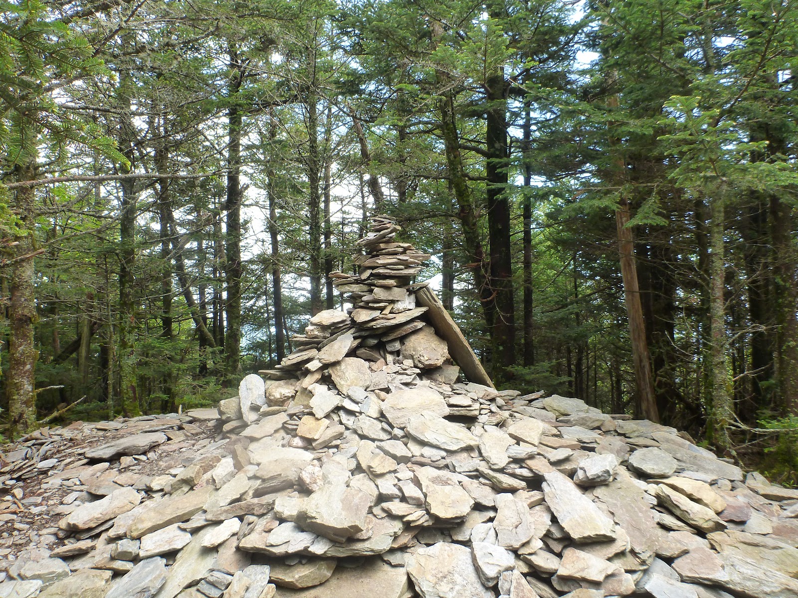
Before reaching the top of the mountain, the Trillium Gap Trail will branch off to your left at 6.6 miles. The summit, better known as High Top, will be at 6.9 miles. You'll know you've reached the highest point on Mt. LeConte when you've reached the cairn, or pile of rocks, just off the main trail on the right.Then one of the most incredible views in The Great Smoky Mountains is only .09 of a mile away called Myrtle Point . Believe me this is well worth the extra mile !
At 6593 feet, Mount LeConte is the third highest peak in the Smokies. However, measured from its immediate base to its highest point, Mt. LeConte can be considered the tallest mountain in the Eastern United States, rising 5301 feet from its base near Gatlinburg.
There is considerable controversy over which member of the LeConte family the mountain was named for. Most people, including the USGS, assume that Joseph LeConte, the famous geologist and charter member of the Sierra Club, is the man for whom the mountain was named. However, that claim has been challenged in recent years. The authors of A Natural History of Mount Le Conte, and the Georgia Encyclopedia, both claim the name honors Joseph's older brother, John, who was famous as a scientist and as president of the University of California, at Berkeley.
Unfortunately you won't have any vistas up at High Top. However, there are two places on the mountain that do afford outstanding panoramic views.
One is at Myrtle Point.
To get to Myrtle Point you'll need to walk another 0.4 miles by continuing on the main trail, which has now turned into the Boulevard Trail. Roughly 0.2 miles from High Top, take the fork off the right side of the trail. Myrtle Point is another 0.2 miles from this junction. This vantage point provides nearly 360 degree views, and is the best location for sunrises on Mt. LeConte
The other place to go for outstanding views is known as Cliff Top, which is near the LeConte Lodge. You will have passed two side trails to Cliff Top, on your right, as you made your way up to High Top. Cliff Top is the best location for sunset views.
One of the unique things about the hike up to Mount LeConte is the lodge and overnight cabins at the top. Hikers have the option of spending the night in the historic cabins which can accommodate about 50 guests a night (you will need reservations well in advance). For more information, visit the LeConte Lodge website.
The idea for the lodge was created when Paul Adams, an enthusiastic hiker and explorer, led an expedition up the mountain with some dignitaries from Washington D.C. to show them the rugged beauty of the Great Smoky Mountains, and to help promote the cause for the creation of a national park. The group spent the night in a large tent. The following year Adams built a cabin on that same spot, which eventually led to the establishment of the LeConte Lodge.
If you're trying to decide which trail to take to Mount LeConte: the Rainbow Falls Trail or Bullhead, I would recommend taking the Bullhead Trail because of the views along the way, (unless, of course, you specifically want to see Rainbow Falls). However, because the Rainbow Falls Trail is less exposed than Bullhead, the Rainbow Falls Trail might be a little cooler in the summer as you ascend to the summit of Mount LeConte.
If you were doing a loop hike, especially during the summer, I would definitely hike up Rainbow Falls Trail and then descend via Bullhead.
The trail begins at the southwest corner of the parking lot. For the first two-thirds of a mile you'll climb steadily over a boulder-strewn pathway, while LeConte Creek cascades down the mountain on your right. There are many opportunities for some great picnic sites along this section of the trail.
The trail crosses over two footbridges, one at 1.7 miles, and the other at 2.4 miles, before reaching the 80-foot high waterfalls at 2.7 miles. Rainbow Falls is the highest single-drop waterfall in the Smokies. It receives its name from the rainbow that's produced by mist and becomes visible on sunny afternoons. During extended winter cold spells, an impressive ice formation builds around the falls. You may notice a little bit of ice just to the right of the falls in the picture on the left.
To continue on to Mt. LeConte, cross the footbridge at Rainbow Falls. Over the next 3.2 miles you'll climb more than 1700 feet before reaching the Bullhead Trail junction. This section of trail will take you past rhododendron, sand myrtle and mountain laurel that offer hikers beautiful mountain blooms during the spring.
At 5.4 miles, you'll arrive at a side trail, which loops back to the main trail after a short distance. The loop leads to Rocky Spur, an outcropping of rocks that offers nice views of the valley below.
At just under 6 miles from the trailhead you'll reach the Bullhead Trail junction. Turn left to continue on to the summit of Mount LeConte.
In another 0.4 miles you'll reach the Alum Cave Trail, which forks in from the right. At this point you'll have your first views of the LeConte Lodge.
A lot people end their hike at the lodge, however, to reach the true summit of Mount LeConte, you still need to walk almost another half-mile.
Before reaching the top of the mountain, the Trillium Gap Trail will branch off to your left at 6.6 miles. The summit, better known as High Top, will be at 6.9 miles. You'll know you've reached the highest point on Mt. LeConte when you've reached the cairn, or pile of rocks, just off the main trail on the right.Then one of the most incredible views in The Great Smoky Mountains is only .09 of a mile away called Myrtle Point . Believe me this is well worth the extra mile !
At 6593 feet, Mount LeConte is the third highest peak in the Smokies. However, measured from its immediate base to its highest point, Mt. LeConte can be considered the tallest mountain in the Eastern United States, rising 5301 feet from its base near Gatlinburg.
There is considerable controversy over which member of the LeConte family the mountain was named for. Most people, including the USGS, assume that Joseph LeConte, the famous geologist and charter member of the Sierra Club, is the man for whom the mountain was named. However, that claim has been challenged in recent years. The authors of A Natural History of Mount Le Conte, and the Georgia Encyclopedia, both claim the name honors Joseph's older brother, John, who was famous as a scientist and as president of the University of California, at Berkeley.
Unfortunately you won't have any vistas up at High Top. However, there are two places on the mountain that do afford outstanding panoramic views.
One is at Myrtle Point.
To get to Myrtle Point you'll need to walk another 0.4 miles by continuing on the main trail, which has now turned into the Boulevard Trail. Roughly 0.2 miles from High Top, take the fork off the right side of the trail. Myrtle Point is another 0.2 miles from this junction. This vantage point provides nearly 360 degree views, and is the best location for sunrises on Mt. LeConte
The other place to go for outstanding views is known as Cliff Top, which is near the LeConte Lodge. You will have passed two side trails to Cliff Top, on your right, as you made your way up to High Top. Cliff Top is the best location for sunset views.
One of the unique things about the hike up to Mount LeConte is the lodge and overnight cabins at the top. Hikers have the option of spending the night in the historic cabins which can accommodate about 50 guests a night (you will need reservations well in advance). For more information, visit the LeConte Lodge website.
The idea for the lodge was created when Paul Adams, an enthusiastic hiker and explorer, led an expedition up the mountain with some dignitaries from Washington D.C. to show them the rugged beauty of the Great Smoky Mountains, and to help promote the cause for the creation of a national park. The group spent the night in a large tent. The following year Adams built a cabin on that same spot, which eventually led to the establishment of the LeConte Lodge.
Adams is also credited with blazing the trail from Alum Cave up to the summit of Mount LeConte.
 |
| Hiking up Rainbow Falls Trail to Mt.LeConte and on to Myrtle Point |
 |
| Have always loved the log bridge crossings while hiking in the GSMNP |
 |
| Rainbow Falls water was very low this time up due to lack of rain fall early in the year |
 |
| Rhododendron blooms still fresh with the morning dew |
 |
| The famous Mt.LeConte Dining Room with date and elevation |
 |
| A beautiful view on the way to Myrtle Point just pass Mt.LeConte Lodge |
 |
| Actual highest point of Mt.LeConte |
 |
| This is my hiking buddy Atti at Myrtle Point enjoying the view .... lol |
 |
| Breath taking views from Myrtle Point |
 |
| Another breath taking view from Myrtle Point |
No comments:
Post a Comment