Sunday, April 21, 2013

Ticks : Information to Know About Them

Although ticks are commonly thought of as insects, they are actually arachnids like scorpions,spiders, and mites. Ticks are among the most efficient carriers of disease because they attach firmly when sucking blood, feed slowly, and may go unnoticed for a considerable time while feeding. Ticks take several days to complete feeding.
Ticks wait for host animals from the tips of grasses and shrubs (not from trees). When brushed by a moving animal or person, they quickly let go of the vegetation and climb onto the host.

Ticks can only crawl; they cannot fly or jump. Ticks found on the scalp have usually crawled there from lower parts of the body. Some species of ticks will crawl several feet toward a host.
Ticks can be active on winter days when the ground temperatures are about 45 Fahrenheit.

It is important to remember that although ticks are thought of as being a threat during the warm weather months of spring and summer, they may also be prevalent during the cool weather of the fall and have even been observed during unseasonable warm weather during the winter. Despite
the time of year, if you are going to be involved in outdoor activities, precautions should be taken to avoid tick bites and tick-borne diseases.
Although at least 15 species of ticks occur in Tennessee, only a few of them are likely to be encountered by people: American dog tick, lone star tick, blacklegged (deer) tick, brown dog tick, and winter tick.
American Dog Tick (Dermacentor variabilis)

One of the most frequently encountered ticks is the American dog tick, also sometimes known as the wood tick. The larvae and nymphs feed on small warmblooded animals such as mice and birds. The adult American dog tick will feed on humans and medium to large mammals such as raccoons and dogs.

Unfed males and females are reddish-brown and about 3/16-inch long. Females have a large silver-colored spot behind the head and after feeding will become ½-inch long or about the size of a small grape. Males have fine silver lines on the back and do not get much larger after feeding. Males are sometimes mistaken for other species of ticks because they appear so different from the female.
In Tennessee the adults are most active in April, May, and June. By September the adults are inactive and are rarely observed. The American dog tick can transmit Rocky Mountain spotted fever, tularemia, and possibly ehrlichiosis to humans.
Ticks


Saturday, April 20, 2013

The Smoky Mountain Hiking Blog: Newfound Gap Road Reopens to Thru Traffic

The Smoky Mountain Hiking Blog: Newfound Gap Road Reopens to Thru Traffic: Great Smoky Mountains National Park officials announced the completion of road repairs to Newfound Gap Road (Hwy 441) this morning. The road has been closed since the January 16th landslide that washed away approximately 200 feet of the road. At 10:00 am on April 15th, the Park officially opened the road to all thru traffic between Cherokee, NC and Gatlinburg, TN.

Park Superintendent Dale Ditmanson, NC Congressman Mark Meadows, Eastern Band of Cherokee Indians Principal Chief Michell Hicks, and Federal Highways Administration (FHWA) Construction Operations Engineer Emmett Melton jointly announced the opening of the road this morning 30 days ahead of the scheduled completion date of May 15, 2013. The National Park Service, FHWA, Phillips & Jordan, Inc. (P&J), APAC Harrison Division, and all subcontractors worked cooperatively in the most efficient and expeditious manner possible to restore Hwy 441 to a safe byway for the traveling public, the gateway communities, and Great Smoky Mountains National Park.

The primary repair contract was awarded to P&J for the submitted bid of $3,989,890.00 with the completion date set at May 15, 2013. The contract included a monetary incentive of $ 18,000 per day to the each day of completion prior to May 15, 2013, up to a maximum of $504,000 offered jointly by the Eastern Band of the Cherokee Indian (EBCI) and the National Park Service.

"We recognize the economic importance of the road to our neighboring communities and are grateful that our partners at Federal Highways Administration and were able to respond efficiently to our need and work with the contractors to make the necessary repairs in less than 90 days," said Superintendent Ditmanson.

APAC Harrison Division completed Phase 1 of the reconstruction project on February 21, 2013 by developing the access road to the slide area, removing of debris, and stabilizing the slope above the work area. P&J mobilized equipment on February 22, 2013 to begin Phase 2 of the reconstruction project which included rebuilding the roadway and filling the area washed away during the landslide with crushed stone.

The final design includes over 200 feet of pipes to allow for the drainage of subsurface water flow along with 150 feet of side drainage leading to a culvert at the end of the slope. This drainage system and previous crushed stone material will further protect the road and park resources from future damage due to both overflow and subsurface water flow. The fill area was naturally sloped and planted with seed. In addition, erosion measures were put into place along the 900 foot debris field below the landslide which was also seeded.


Jeff
Hiking in the Smokies

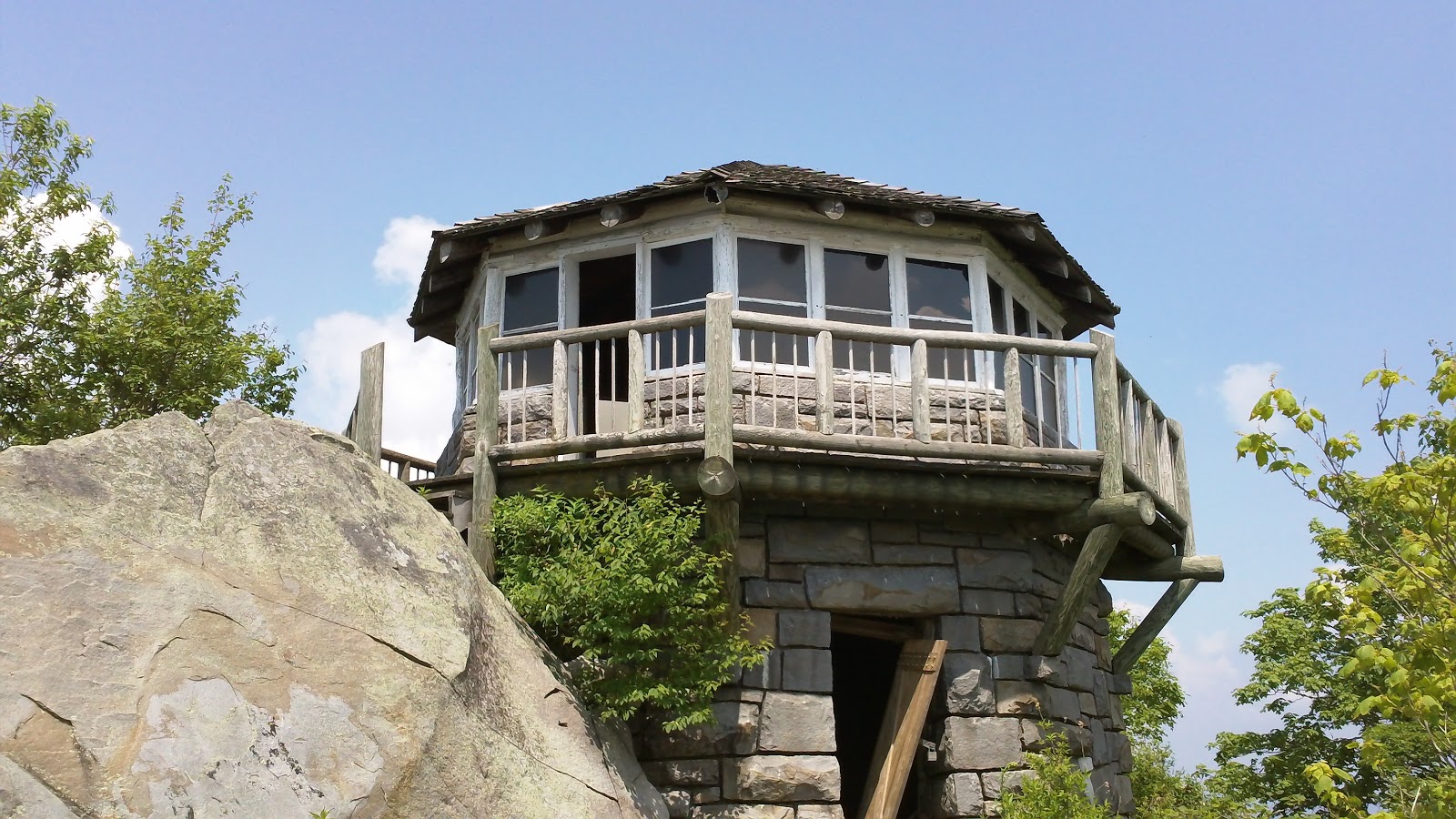
Mt. Cammerer FireTower In The GSMNP

Mount Cammerer is a mountain on the northeastern fringe of the Great Smoky Mountains, in the Southeastern United States. The mountain is situated on the state line between Cocke County, Tennessee and Haywood County, North Carolina. The Appalachian Trail traverses Cammerer's south slope and a restored fire lookout at the summit offers panoramic views of the eastern Smokies, Cocke County, and the Blue Ridge Mountains.

Although a narrow ridge connects Mt. Cammerer to a nearby higher knob, leaving Cammerer with a very low topographic prominence, the mountain is clearly visible not only from the surrounding mountains, but from various points in the town of Cosby and along I-40 as it crosses Cocke County. Mt. Cammerer is a popular hiking destination, especially in Autumn, when the leaves of the trees in the forest around the mountain blaze red, orange and yellow for as far as the eye can see.

History --

Mount Cammerer was named for Arno B. Cammerer, Director of the National Park Service (1933–1940) and an instrumental figure in establishing a national park in the Great Smoky Mountains. Before its renaming, Mt. Cammerer was known as "White Rock," referring to the bright white rocks that burst through the treeline at the summit. On some North Carolina maps, Mt. Cammerer is called "Sharptop". At least one story tells of a lightning blast that cut a hole in the summit, leaving a pool of water that attracted ravens.

Throughout the late-19th century and early 20th-century, moonshining was rampant in the area around Mt. Cammerer, as what was then a virgin wilderness provided the perfect cover for the illegal stills. Most residents in the area, however, were law-abiding mountain farmers, as described in local resident Mary Bell Smith's In the Shadow of the White Rock. Ella Costner, designated by the state of Tennessee as the "poet laureate of the Smokies," was born in the area of what is today the Cosby Campground, at the base of Mt. Cammerer. In 1934, the Civilian Conservation Corps built a camp at the base of the mountain, and constructed most of the trails and overlooks in the area.

The lookout at the summit of Mt. Cammerer was built by the CCC in 1937, using nearby rock and timber (other materials had to be hauled up the mountain). The tower was manned by a fire ranger until the 1960s, after which it fell into disrepair before being restored in 1996.

Hiking Routes --

The quickest route to the summit of Mt. Cammerer is to ascend the Low Gap Trail from the Cosby Campground to the Appalachian Trail at Low Gap. From Low Gap, it's just over two miles to the Mt. Cammerer Trail, which follows the ridge a half-mile or so to the summit. The total distance from the Cosby Campground to the summit is just over five miles.

The Lower Mount Cammerer Trail follows the mountain's northern base over a seven-mile up-and-down trail before intersecting the Appalachian Trail near Davenport Gap. Most hikers who use this route make the following loop: Cosby Campground , Lower Mount Cammerer Trail , Appalachian Trail , Cosby Campground. The Appalachian Trail intersects the Mount Cammerer tower trail along this route. The total distance, including the tower trail, is appx. 15 miles.

Multiple hiking trails, horse trails, and walkways intersect at the Cosby Campground, which can lead to confusion. From the parking lot (near the campground), one path leads east to the Lower Mount Cammerer Trail. To reach the Low Gap Trail, simply follow the path parallel to Cosby Creek. Both trails are marked.

The Smoky Mountain Hiking Blog: Appalachian Trail Enthusiasts to Meet at Western Carolina University for 39th Biennial Conference

The Smoky Mountain Hiking Blog: Appalachian Trail Enthusiasts to Meet at Western C...: Registration is now open for the 2013 Appalachian Trail Conservancy (ATC) Biennial conference, scheduled for July 19-26, at Western Carolina University in Cullowhee, North Carolina. The event is hosted by the five southern Appalachian Trail (A.T.) maintaining clubs and convenes Trail managers, hikers, and fans to celebrate and conserve the iconic National Scenic Trail.

The program includes 137 organized hikes, 70 workshops, live music, dancing, and trips to some of the region’s best activities.

Hikes are planned on the A.T. and other regional trails. Workshop topics cover hiking, trail maintenance, natural wonders, cultural history, and volunteer leadership development. Activities include rafting, zip-lining, touring Asheville’s booming art scene, and visiting the Carl Sandburg Home and the Biltmore Estate.

“This event is only held in the southeast once every eight years, so the Appalachian Trail Conservancy is excited to bring this informative and entertaining event to North Carolina to showcase the Appalachian Trail and the surrounding beauty,” Morgan Sommerville, regional director of the ATC.

Organizers expect 1,000 participants of all ages for the celebration of the A.T. The Biennial also serves as the general business meeting of the ATC’s membership; this meeting will take place on Saturday evening, July 20th.

Contra dancing, music from Southern Exposure and Buncombe Turnpike, presentations about hiking long trails, and a Cherokee storyteller make up the rest of the evening entertainment scheduled Sunday through Thursday. Evening activities are open to the public with a $7 nightly ticket.

The ATC was founded in 1925 by volunteers and federal officials working to build a continuous footpath along the Appalachian Mountains. The A.T. is a unit of the National Park System, stretching from Georgia to Maine, at approximately 2,180 miles in length. It is the longest hiking-only footpath in the world. Volunteers typically donate more than 220,000 hours of their time doing trail-related work each year, and about 2 to 3 million visitors walk a portion of the A.T. each year.

Saturday, January 26, 2013

Smokies Announces Implementation of Backcountry Ca...

The Smoky Mountain Hiking Blog: Smokies Announces Implementation of Backcountry Ca...: Great Smoky Mountains National Park officials announced today that changes to its current backcountry reservation and permitting process will take effect on February 13, 2013. As reported last March, the National Park Service approved the park's proposal to begin collecting fees for use of the park's backcountry campsites and shelters. The changes include a $4 per person, per night fee for backcountry camping. The fee will be used to provide increased customer service for backcountry trip planning, reservations, permits and the backcountry experience.

A park-specific reservation and permit system, to which users will have 24/7 access, will allow backcountry campers to make reservations and obtain permits online from anywhere internet access is available. Reservations may be made at any time up to 30 days in advance, allowing maximum flexibility for those making last minute plans. Backcountry users will no longer be required to call the Backcountry Office to obtain reservations. Reservation and permit requests will also be accepted in person at the Backcountry Office, which is located at the Sugarlands Visitor Center.

Backcountry Office hours will be expanded with additional staff available to provide trip planning assistance both over the phone and in person. In addition, the park will expand its backcountry Ranger presence to better protect park resources through enforcement of food storage and other regulations and improved visitor education regarding Leave-No-Trace principles.

For more information about the changes, please visit the management page or call the park's Public Information Office at 865-436-1207. For general backcountry information or backcountry reservations, call the Backcountry Office at 865-436-1297. On February 13, backcountry reservations and permits will be available at www.smokiespermits.nps.gov.

Wednesday, December 5, 2012

Man Arrested for Breaking into Cars in the Smokies

The Smoky Mountain Hiking Blog: Man Arrested for Breaking into Cars in the Smokies:

From NPS Digest:

While conducting a surveillance operation on the morning of Sunday, December 2nd, a ranger saw what appeared to be a man breaking into a vehicle parked at the Chimney Tops Trailhead on Newfound Gap Road. The man then left the area in a Ford pickup. When rangers attempted to stop the truck on Little River Road west of Sugarlands Visitor Center, the man fled and continued to elude rangers until he exited the park at the Townsend Wye. Once outside the park, rangers turned over the pursuit to Blount County Sheriff’s Office deputies, who took the 38-year-old Tennessee man into custody after he crashed his truck.

Rangers and special agents subsequently confirmed the theft of property from a visitor’s Ford Explorer parked at Chimney Tops Trailhead. The investigation of the offenses occurring within the park continues; federal charges are anticipated.


Jeff
Hiking in the Smokies